2014-02-11 52 5
| Tue 11 Feb 2014 in 52,5: 52.5562134, 5.7804640 geohashing.info google osm bing/os kml crox |
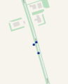
Location
between the ketelmeerweg and a ditch separating it from a field
Participants
Plans
Take a small detour on the route to work and get there at sunrise. This one ought to be easy and therefore suited for me.
Expedition
Found the spot without any hardship, and parked the car at a marker commemoraing that this land is man made, and a century or so ago ships were still sailing 5 meters above where there now is a road. I was there at 8.04, so 2 minutes after sunrise as it turns out, but the sun was obscured by clouds, or would have been obscured by a farm at the other side of the road anyway, so there was no chance of being hit by the rays of sun as it peeped over the horizon anyway.
The hash was next to the road, and i walked along, and marked the spot. Then decided to drive back through the ahsh instead of getting on the road immediately. As far as planning goes, I also decided to take a picture driving through, at a speeds of ~20km/h. Max allowed speed on the road would be 80 km/h, but that is not applicable off road.
Photos
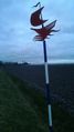
marker to show that you're far below sea level; approx 40 m from hash. park car here

walking around to get a low reading on the droid app

Me walking around
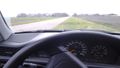
might as well get onto the road after passing though the hash. Not sure about speed limits off road though