2014-03-24 51 -0
| Mon 24 Mar 2014 in 51,-0: 51.2015917, -0.9426698 geohashing.info google osm bing/os kml crox |
Location
A field near Odiham (near RAF Odiham, where they fly Chinook helicopters). The geohash is between a small windpump and a fence.
Participants
Plans
This geohash is only about 12 miles from my home, so I decided to make my very first expedition. I programmed my Tom Tom with the lat-long, and took a printout of the close-up Google maps location.
Expedition
The car sat-nav took me right alongside the field. There were a couple of people leaning on the gate to the field. When I stopped the car they nodded at me and I wondered whether they were also there for the geohash (however unlikely that may be). They said they lived there (there is a house just near the field). I explained that I was there for something like a geocache, and one of them knew about that (which was a big win). So I then explained that it was like a geocache, but just to get to a particular point around 4pm. They said that would be trespassing, so I said I would just have to take the photos in the road. They then said I was welcome to go into the field.
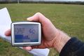
They asked what was to stop me just claiming I had been there, and I explained about taking a photo of the sat-nav.
I climbed through the fence, into a field with a couple of horses, then through another fence into the field where the hash point was. I was surprised how sensitive the lat-long reading on the sat-nav was. I only needed to move a step for the reading to change. it was pretty much impossible to get both lat and long exact to the resolution of the reading on the device, but I stepped to and fro, getting first one then the other exact, so certainly covered the exact point.
The Google map led me to exactly the right place, just level with the wind pump.
Photos
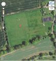
Google map of the hashpoint.
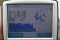
one GPS reading within half a pace of the right spot...
...and another.

This is me to prove I was there (see base of wind pump behind). Not easy to take a selfie on an SLR without a reverse screen.
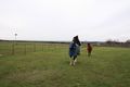
The horses in the field.
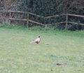
A rather nice pheasant (should have used the camera zoom).


Achievements
- Land Geohash