2014-04-16 52 4
| Wed 16 Apr 2014 in 52,4: 52.2914580, 4.4657704 geohashing.info google osm bing/os kml crox |
Location
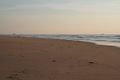
On the beach near the NORA station, maybe in water depending on the tide.
Participants
- Palmpje
- Ellipse (ninja hasher)
Plans
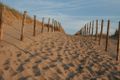
Planning started as soon as the coordinates were announced. Finally a 52,4 hash that was almost not in the sea and reachable as well! Palmpje thought he could squeeze it into his evening plans, having to work in Amsterdam all day and Ellipse announced later that he might try it. After checking the tide tables Palmpje decided it would be best to go as late as possible as the high tide would be around 17:30 (well late in the afternoon) and it would be near the peak of the moon cycle. On the IRC channel there was a long planning discussion on doing a tron here. As Palmpje lives very near the haspoint (4.3km as the crow flies) he was able to give directions. Ellipse said he'd probably go late afternoon but we would try to keep in touch over IRC - which proved to be rather hard.
As expedition time approached Palmpje got in a squeeze and decided he would go by car announcing: Try a tron with car, will be hard to achieve.
Thinking it over a bit this would be sort of impossible given the approach opportunites and parking spots available. So no tron for Palmpje.
Expedition
As told by Palmpje: When I logged onto IRC at around 6pm hashie told me that Ellipse would be there past 7pm (if he went). Checking the home evening schedule this turned out to be good planning and I ended up leaving home around 7:20pm. That would put me on the beach past 7:30pm but I was not really expecting to meet anyone, despite Ellipse's messages. The way to the hashpoint was really familiar as I sometimes run on the path leading to the beach. There is a golf course at the left hand side of the path and a group of golfers was mistakingly trying to land a ball on the hashpoint. There were at least 100 balls lying around on a green! Little did they know that the point was about 400m to the north-ish. At the end of the bicycle path I spotted what later proved to be Ellipse's transportation in a conspicious parking arrangement. My hopes of an actual meetup grew and when I reached the crest of the last dune I was sure that I saw Ellipse at the hashpoint, or rather the point he had determined to be that point. Trouser legs rolled up, the water coming to his calves and small waves breaking around his legs. What a sight!
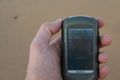
Anyway, I walked down and waved with my GPS. After removing my shoes and socks and rolling up my trouser legs I joined Ellipse in the water. It was only then that I checked my GPS and found out that the actual hashpoint was above the current tide! All that fuss for nothing. This shows that a dedicated GPS is probably more stable than a phone GPS. Anyway we enjoyed the views, and made some pictures. Of course I included the NORA tower. I remembered last spring when I met Murfie and we could not legally reach the hashpoint. Because I was pressed for time I wanted to get back home again. So we climbed up again with Ellipse carefully avoiding his inbound track as he was still on a tron mission. We said - or rather waved as I was having to make a call - our goodbyes and as a true ninja Ellipse left all te writing to me.
Tracklog
Photos

Hashcycle?
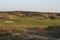
Confused golfers

Found a ninja
Exactly here!

Apologies for the lighting
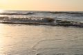
Always nice views at the beach
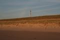
Top secret tower
Shrimp fishing?
Despair?


Achievements
Palmpje and Ellipse earned the Land geohash achievement
|