2014-04-25 46 -1
| Fri 25 Apr 2014 in 46,-1: 46.6685405, -1.7238068 geohashing.info google osm bing/os kml crox |
Location
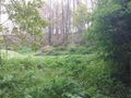
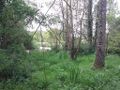
In a forest near La Chapelle-Hermier.
Participants
Plans
I was in holidays in 47,-2. This is my birth graticule, and it was still virgin.
Expedition
I'm editing this on 2014-09-07, I am very late. Since it was 75 km away from where I was, I took my car. I decided to park in La Chapelle-Hermier and then walk to the geohash, but the road was quite unfriendly for pedestrians. So I managed to park in a little road closer to the geohash, hoping I would not disturb anybody while I was away. After maybe a 10 minutes walk, I was close to the geohash, which was not too far from the Jaunay river. Since I was under trees, my phone kept losing the GPS signal and it was very difficult to orient myself even with the Geohashing application... I need that Garmin eTrex! The picture with the coordinates is 83 meters away from the geohash, according to the haversine formula (thank you Emacs). Since I walked quite a bit in circles, I think I went closer to it than that, but I was difficult to monitor both my phone and GPS. This is why I'm going to give myself this geohash :)
Photos
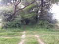
On the way...
On the way, part 2
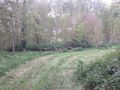
Close!
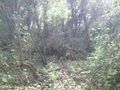
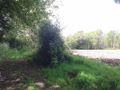
Around the geohash
Around the geohash bis
Around the geohash ter
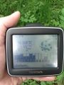
The best coordinates I had in a picture


Achievements
Beltxarga earned the Land geohash achievement
|
Beltxarga earned the Graticule Unlocked Achievement
|