2014-05-03 43 -121
| Sat 3 May 2014 in 43,-121: 43.9335309, -121.3084585 geohashing.info google osm bing/os kml crox |
Location
At the very top of the La Pine, Oregon graticule (just south of Bend) in the Deschutes National Forest near a buried gas pipeline.
Participants
Daisy
Plans
Google maps shows it just .3 mile off of a forest road. How hard can this be?
Expedition
You know those perfectly straight cuts through the forest where power lines run? Well, that's what this looked like on the satellite map images. And the maps showed a road running along the cut! Well, I found that this "road" was a very rocky dirt track that I could definitely not take my low-clearance minivan down. So I parked the car, and Daisy (my dog) and I walked.
I wasn't sure at first why this perfectly straight swath of forest had been cut--there were no power lines. Eventually, signage along the way clued me into the fact that I was walking along a high-pressure buried gas pipeline. If you feel the earth shake, don't light a match!
There were lots of bullet casings along the "roadway", and some randomly placed jugs of water.
It was only about 2.3 miles each way, but when you're walking in a straight line, that seems to take forever. It was almost a relief to veer off the straight path for the last few thousand feet. I even found some ATV and motorcycle tracks to follow in order to get me closer to my destination. Much better than bushwhacking through the fireweed and manzanita bushes!
Once I was done, I was off to dinner with friends. I had to explain the difference between "geohashing" and "geocaching".
Tracklog
Photos
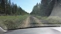
Road not suitable for a minivan
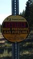
Ah! There's a pipeline buried under here!
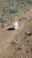
One of several strangely deposited bottles of water in the roadway
Proof!
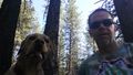
Goofy grimaces


