2014-05-14 50 11
| Wed 14 May 2014 in Erfurt: 50.6544701, 11.9718041 geohashing.info google osm bing/os kml crox |
Location
Today's location is at a tiny brook at Zeulenroda. With GPS accuracy, the spot could be either on one side of the <50 cm wide brook, on the other side, or - and I'm using this one because of the Rule of Cool - in the brook.
Country: Germany; state: Thüringen (Thuringia, EU:DE:TH); district: Greiz
Weather: alternating between light rain, strong rain with tiny hailstones, and sunshine
Expedition
Danatar
This was my trip to Dresden to start a new job the following day. My car was full of stuff I'd need, including my bike. And of course I went geohashing on the way. The first part of the journey was uneventful. Light rain and sunshine alternated. Near Hof I didn't change the Autobahn, instead I stayed on the A9 until the Schleiz exit. The road from Schleiz to Zeulenroda was closed so I followed the detour signs via Oettersdorf and Tegau to Pahren. There the rain became much stronger. I reached the retaining lake while tiny hailstones were added to the downpour, but I got out of the car to take a picture nonetheless. I got wet because getting the umbrella from the depth of the car's trunk took a while. Only moments after I continued my journey the rain stopped, because the cloud had moved on.
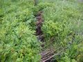
At Zeulenroda I easily found the street that lead to the hashpoint, it was raining only slightly. I saw the small brook with the hashpoint after only a few steps along a small track and I could see that it was in the middle of a meadow. A meadow that was very wet after all that rain. I followed the track for a while, trying to find a better approach to the hashpoint, but without success. I had my running shoes in the car and I wanted to use them to preserve my everyday shoes from the wetness, but I knew that they were so far below all the other stuff (and the bike) that I couldn't reach them. So I did what every sensible geohasher would have done in my place, I just walked through the wet grass. It went up to my knees, so my shoes and lower legs got thoroughly wet after only a few steps. The geohashing dance was complicated by the brook, but a large step took me to the other side, then the GPS showed the spot while I was standing next to the water. Since it was still raining, I took the pictures as fast as possible, then I went back to the car.
Luckily both my good shoes and clean socks were accessible, so I changed into dry stuff, except for the pants. Then I drove to the main part of the retaining lake to take pictures in the sunshine. Afterwards I continued my journey, driving via Greiz and Reichenbach to the Autobahn A72, then to Dresden. In total, the detour for the geohash added 30 km and 1.5 hours to my trip, so I arrived at Dresden later than planned.
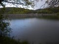
retaining lake with forebay dam near Pahren (rain, some tiny hailstones)
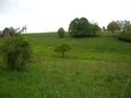
almost there
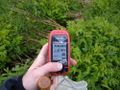
GPS
the hashpoint

Coordinates reached (rain)

panorama
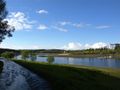
retaining lake at Zeulenroda (sunshine)


