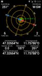
2014-05-24 47 11

| Sat 24 May 2014 in 47,11: 47.3266421, 11.7578641 geohashing.info google osm bing/os kml crox |
Because of Memorial Day on Monday the coordinates for the four consecutive days Saturday through Tuesday were announced on Friday afternoon. This is a rare event, and even more lucky that Mouse Over Day (May 24 this year) and Towel Day (May 25) are included and that all four coordinates are within reach and more or less accessible. I will try to reach them all, but the weather forecast for an alpine tour on Tuesday is problematic. We will see. Update: The weather is indeed too unstable on Tuesday, so three consecutive hashpoints have to be enough for this time.
Location 1 of 3 consecutive
Above Schwaz near Proxnalm.
Participants
- LeslieHapablap (previous|next)
- Waltraud the hashkiwi.
Plans

Go to Schwaz, then hike up the mountain to the hashpoint (planned arrival at 1 pm). Maybe walk the additional 2 km to Proxnalm for a lunch. If everything goes well, this is the first of four consecutive expeditions in the next four days. We were not blessed with many good points during the last couple of months, but this weekend plus Monday and Tuesday have awesome hashpoints.
Expedition

This is what I learned on this expedition:
- When geohashing above the timberline, always bring gloves even in late May, and a spare pair of socks!
- Prefer steeper sections without snow to snowfields, unless you happen to have snow shoes with you.
But more on that later. I knew from the route profile that this was going to be exhausting, with over 1000 m (3300 ft) difference in altitude and almost 20 km (12 miles) distance to walk. On top of that, the very last stage of leaving the trail to approach the coordinates is often very difficult in this terrain.

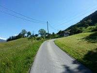
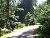
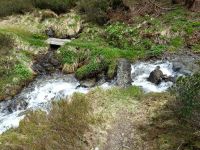
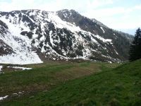
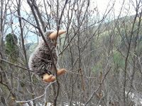
It all started of as a beautiful Mouse Over Day with sun and pleasant temperatures. I went to Schwaz by car and started to hike, on the first part of the route I could walk on quite broad forest roads. Therefore I made some good distance and altitude quickly, and on my way I even spotted a roe deer. After six kilometers I had to leave the forest road and walked up a skiing slope for a while, which looks very strange in summer: like a highway down the mountain completely free of trees, some abandoned skiing lifts, overall not a cheerful sight. Luckily it was only a short passage, then I was on a hiking trail which took me to the timberline. I made a short break and attended to my lunch bag, then continued to cross a stream and went further up to the Old Proxnalm Hut, which now days seems to be closed down and unoccupied (the new one is still operated). The terrain and weather conditions became a bit more unfriendly and I was glad that I brought warmer clothes with me. The surrounding summits were still covered in snow, and on one of the distant mountain slopes, contrasting against the snow, I saw what was probably a fox, even though they are rarely encountered above 1800m.

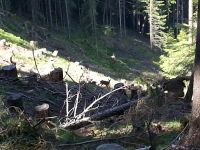
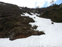
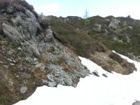
After approximately 10 km at 1 p.m. my GPS told me that the hashpoint was about 200 m away and it was time to leave the trail. I needed additional 30 minutes to finally reach the point, and that says everything about the terrain and conditions. It was the whole package, some parts to climb, some parts through thick vegetation, some rocky passages with deep gaps in between. I had to pass snow fields which often wouldn't support my weight and I found myself standing in snow to the knee. I was aware that snow fields are an underestimated threat in the mountains, responsible for many severe and even fatal accidents every year because if you trip you possibly cannot slow down on the icy surface. In this case, whenever I had to cross a snow field I made sure that the upper layer was soft snow for a safe stand, and I always tried to choose near level passages. Now I wished for gloves because I had to grab into the snow now and then, and for a spare pair of socks because of all the snow that got into my hiking boots. Finally I reached the coordinates, which were situated within thick and tall vegetation.
On my way back to the trail, as always, I made some better decisions. By taking a slightly steeper route around them I could avoid some of the snow fields, which saved me quite some time. I was very glad once I arrived at the trail. Because I started to get tired and some threatening rain clouds came over the mountaintops, I decided not to make the extra 2 km to the New Proxnalm Hut, but instead immediately return on the same route I came. The way back was uneventful but exhausting, I really felt my legs after the descend.
Photos
Obligatory proof.
Wasn't expecting to be standing in snow to the knee later that day.
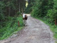
The road was guarded by a distrusting cow.
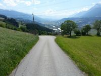
Made good progress on this forest road.
The roe deer.
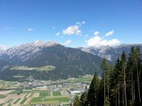
Schwaz and the mountain of an earlier expedition.
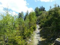
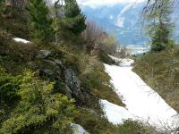
Now on a hiking trail.
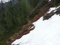
A snow field covers the trail.
Slippery when wet.
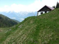
The Old Proxnalm Hut.
Off-trail.
Still climbing.
Almost there.
Finally there, Waltraud is happy, too.

Obligatory silly grin.
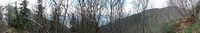
Panorama of the hashpoint.
Returning to Schwaz.


Achievements
LeslieHapablap earned the Land geohash achievement
|
LeslieHapablap earned the 2014 Mouse Over Day achievement
|