2014-08-02 44 -123
| Sat 2 Aug 2014 in 44,-123: 44.9228439, -123.4103215 geohashing.info google osm bing/os kml crox |
Location
In a hilly area in a logging company forest west of Dallas, Oregon.
Participants
Plans
Ride 75 or so miles on my bike. This seems doable.
Expedition
This is the longest bike ride that I've done by about a half, so I prepared far more than I usually would have. This turned out to be a good idea! I packed a lunch and snacks, two liters of water, and wore sunscreen. I left at about 7 in the morning, and it was gorgeous out. The ride up to Monmouth was pleasant; it took about two hours, and then it was another hour or so until I got to Dallas. Unfortunately, the road up to the hashpoint was gravel and steep, so I had to walk.
It was probably about 2.5 hours of walking until I got to the hashpoint. The last 300 meters were straight through a bunch of blackberry bushes and sneaky poison oak that I didn't notice until it was too late. The blackberry bushes made the walk agony, and as I sit here writing the poison oak is even more agony. Oh well, I got the success! Snapped a picture and then beelined for the road. I couldn't stand being in that area for much longer.
I stopped in Dallas City Park. It was pleasant! Everyone and their mother was having a birthday party, but I found an empty picnic table and had my lunch. I was able to fill up my water bottles, which was good because they were empty at that point.
On the way back to Corvallis I stopped by Second Chance books in Independence. I can recommend them! Very good selection, and the books are organized well.
The ride back from Monmouth was the longest stretch, but not that much more difficult. It was slow because I was really tired, so I coasted most of the way. I made it home, though, and less than 12 hours after I left! (11.75)
Tracklog
Photos
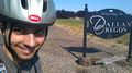
In Dallas!

Not goofy, but exasperated!
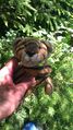
The hashscot posing next to some local foliage.


Achievements
Frogman earned the Bicycle geohash achievement
|