2014-08-03 47 11
| Sun 3 Aug 2014 in 47,11: 47.9887592, 11.3096274 geohashing.info google osm bing/os kml crox |
Contents
[hide]Location
The geohash is on or next to the street between Maisting and Starnberg.
Who Went
TheOneRing - by public transport.
The Expedition
I started at 11am with a train to Starberg via Weilheim. The weather was really good, sunny and warm so far. From the train station the geohash was 2.5km as the bird flies. I left the city in western direction coming quite fast to an area with crop fields and forests. I walked into one forest and here the fun part started: yesterday, it rained a lot in the afternoon and the air was still humid. With the humidity and the warm temperatures it was quite nasty...at least for me (others may deal better with these conditions).
But well, no complaining anymore, I arrived at the geohash, which was next to the street. In fact, it was directly next to the shoulder and the beam barrier. Several meters next to the beam barrier, a military restricted area began. Consequently, a little bit further in that direction and the geohash would not have been reachable. Fortunately, I did not (and would not anyway) violate the restricted area. German military authorities do not find this kind of violation very funny, but it might not be different to other countries.
I took the usual photographs but the surrounding was not very impressive (forest - street - forest), I walked back to Starnberg. With a little time left I bought an ice cream cone and took the following train home.
Photos
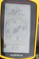
Coordinates reached
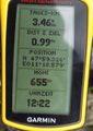
Some more information

The happy hasher, my eTrex still marks the geohash
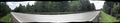
The street, I waited for an interval without cars
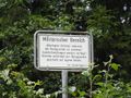
Whew, lucky me, no violation of the restricted area


Achievements
TheOneRing earned the Land geohash achievement
|
TheOneRing earned the Public transport geohash achievement
|