2014-08-26 -12 130
From Geohashing
| Tue 26 Aug 2014 in -12,130: -12.4704084, 130.9720500 geohashing.info google osm bing/os kml crox |
Location
On a footpath in Palmerston.
Participants
Expedition
Not much to this one. I jumped on my bike after work and rode down the dark old Stuart Highway rail trial to Palmerston. I negotiated the streets, found the hash, took the photos and returned via dinner at the Palmerston Maccas.
The only obstacle was a large section of the Palmerston streets being blocked off with temporary fencing for road works. My slavish following of Google Maps saw me move the fence out of the way at one end for access, and negotiate a large conduit trench at the other end to get back onto public land, weirding out a local resident in the process.
I rode 44kms and reached the hash at 8:55pm.
Here is the route of my trip.
Photos
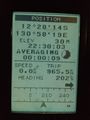
GPS

Felix at the hash
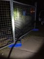
Fenced off hash-road


Felix Dance earned the Bicycle geohash achievement
|