2014-09-01 63 27
| Mon 1 Sep 2014 in 63,27: 63.0341211, 27.7300125 geohashing.info google osm bing/os kml crox |
Location
In Kasurila, Siilinjärvi. The point is in forest in the slopes of forested hill Kasurilanmäki.
Participants
- Tilley
- Tilley's daughter
Expedition


I had often longingly gazed upon those hashpoints that fall on the very southern edge of the graticule - then the point in the graticule northward would be rather close to me. However, this far these points have been still a bit too far, or other conditions haven't been suitable for a trip. So the northern graticule was still unvisited by me. But now everything fell in place!

The hashpoint was located in Kasurilanmäki, Siilinjärvi. The point was only a few hundred meters from the old main road 5, the route was straightforward with good (well, as good as they get in Finland) cycleways and the weather was dry, temperature being quite normal for this time of year, about 10 degrees Centigrade. Although that feels a bit cold when you step outside, because 3 weeks ago there was still +25, and you can only adapt to a 1 degree chance in a week (my brother the indoor climate expert tells me).

My daughter the geohashtoddler had a bit of a flu, but that was actually speaking in favor of making the expedition; she would sleep her day nap better in a more upright position and in the outside air. With good woollen trousers and shirt (made by granny), coverall and a blanket she would stay warm, too.
After the lunch, when naptime was approaching, we packed and left. There was about 25 km to go. There was a slight breeze from behind us, and the cargobike was almost flying forward. About half a way there my average speed was about 21 km/h, then it dropped a bit because the terrain started to get hillier. The toddler had fallen asleep quite soon after the departure. The air was fresh and the cycleways clean. I found all the right intersections easily and the whole trip went without problems.

When I turned from the final intersection to the road leading to the top of the hill, my daughter was still sound asleep. About 30 meters of vertical climb and we were as close as we could get to the hashpoint by road - about 90 meters to go. I ate some of the provisions we had and took a moment to catch my breath. The toddler already seemed to be stirring more, so she was about to wake. In a few minutes she indeed awoke, and was in an instant ready to go hashing - if she would get some raisins.

She received her treasure, the raisin bag, and we started towards the hashpoint. The terrain was the usual hard-to traverse forest consisting of thickets, boulders and small birch trees felled to zig-zag-pattern. The toddler had of course to be carried, she couldn't have take a single step without falling in this terrain. Furthermore the GPS was having a bit of a trouble in the thickets, so we had to geodance a bit. After a while more satellites rose to the view and we located the spot with about 1 m accuracy. I couldn't get a picture of that, but 2 m should suffice. Another graticule to my list!

With pictures for proof taken, we headed back to the bike. On the way I picked some lingonberries. They were quite ripe and good to my taste, but the toddler still preferred raisins. We then headed homewards. The toddler was now awake, and there was a lot to wonder along the way: a convoy of road-marking vehicles, a train heading for the paper board factory, some tractors and a couple of big excavators (those were a bit scary, she said).
After about 40 km of cycling my legs started to feel quite sore, but that surprisingly didn't affect the speed as much as I felt it did. We arrived safely home still in time for the dinner.
Distance cycled: 51 km. Average speed: 19,1 km/h.
Additional photos
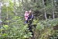
Standing on the point.
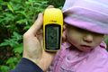
Distance to the hashpoint 1,89 m.
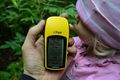
The gps location proof.
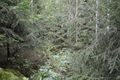
The view from the hashpoint into the thickets.
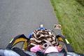
Driver's view.


Achievements
Tilley achieved level 4 of the Minesweeper Geohash achievement
|
Tilley earned the Bicycle geohash achievement
|
Tilley&daughter earned the Land geohash achievement
|