2014-09-06 63 28
| Sat 6 Sep 2014 in 63,28: 63.6391881, 28.5978058 geohashing.info google osm bing/os kml crox |
Location
Near the village of Rapuli, Valtimo. The point lies in the forest.
Participants
Expedition

I was visiting Pastori with my family. Weekend's hashpoints turned out very favorably, Saturday's 15 km and Sunday's 5 km, as birds fly. We had done a long lingonberry-picking trip on Friday, so on Saturday no one else but me was in a hashpoint-trip-mood. A rare chance to do a bicycle ride on my own, I immediately grabbed it.

As I have previously mentioned, Finlands forest-road network is very extensive, mainly for the purposes of efficient logging industry. Thus it was no problem getting to the vicinity of the hashpoint via roads, if only I could find the right turns on the maze of the roads. Google maps said about 24 km one-way to the hashpoint. The whole distance was on gravel roads of varying shape.

After breakfast I packed my stuff and started the expedition. The first kilometers were very familiar roads, and I could concentrate on looking around. You could feel the autumn coming in fast. On the night before, temperature had dropped to +4, and there was a lot of dew everywhere. The air was fresh. Leaf trees were turning yellow. There were a lot of mushrooms everywhere, even lining the road.

I had memorized the route quite well and had also a hand-drawn map of the route. Finding the right way proved not to be especially difficult. The logical route through the maze of roads can usually be found by following tire-tracks on the intersections. Because the expedition had been so easy, I decided to make it a bit more difficult - I would take a short cut. By cutting straight through forest between two dead-end forest roads, I would save about 2-3 km. The distance needed to cross in pathless forest was about 500 meters. I lifted my bicycle to my shoulder and started trudging. Right on the first few tens of meters it became clear this was not a faster way than going around would have been. The thicket was quite - well, thick. After a while, the forest became much easier to travel. My going didn't get much faster, though - because there were a lot blueberries I couldn't resist! So this turned out to be at least a lot yummier short cut.

After the short cut the rest was easy. Just a couple of kilometers and a few turns, and I was at the road closest to the hashpoint. About 280 m to go in a nice, open forest. While walking, I ate some rye bread, picking blueberries and lingonberries as relish. When getting deeper into the forest, deer flies started homing on me and I had to constantly fend them off my neck and hair. Stupid creatures, do I look like an elk? Despite all this, I was soon at the hashpoint. Right on the spot there was a hummock, on which there were both blueberries and lingonberries growing. Nice!

After the necessary pictures, I returned to my bike and started the return trip. This time I decided not to use the "short cut". :) On the long way, there were some roads that were in quite bad shape. Actually there were so large bumps and steep hills, that I at some point lost my bottle-holder along with the water-bottle, and didn't even notice, when. Rest of the equipment I managed to carry intact back to Pastori's place.
Trip statistics: cycling 45 km. Walking 1 km. Average speed 18,6 km/h (including all the walks and bike carryings and such), maximum 45,4 km/h.
Additional photos
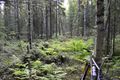
Another picture from the short cut.
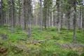
A view from the hashpoint.
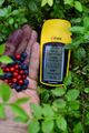
A picture of the coordinates (and of the blue- and lingonberries that were growing straight on the hashpoint).


Achievements
Tilley earned the Bicycle geohash achievement
|
Land geohash.