2014-10-25 42 -87
| Sat 25 Oct 2014 in Kenosha: 42.0818289, -87.7737192 geohashing.info google osm bing/os kml crox |
Contents
[hide]Location
Residential road in Wilmette next to the Wilmette Golf Club.
Participants
Plans
Planning on going in the late afternoon. -Haberdasher (talk) 12:58, 24 October 2014 (EDT)
Expedition
After the weekend hashpoints were released on Friday, I told me mother, "Gee, if we were going to visit my step-grandmother on Saturday, this hashpoint would be good!" She then told me that she had already planned to visit my step-grandmother with me on Saturday. And the planning began! As it turned out, the hashpoint wasn't quite as on the way as I thought it was, but my mother was a trooper- it helped that it gave her an excuse to hit up a local deli.
The GPS guided us to a road which had a sign that said Wilmette Golf Club on it. My mother expressed hesitation about continuing and said that we'd see how far we could get, while I, assisted by having previously scoped out the location on Google Maps (and having recently had laser eye surgery, which quite naturally has given me laser eyes), pointed out that the sign also said "Open to the public". As I had suspected, the hashpoint was not in the golf club itself, but in a cute, quiet residential neighborhood which backed up to the club. A bit of worrying about where to park, a bit of the GPS dance, and the hashpoint was reached with little fuss.
And then, in the course of convincing my mother to take a picture of me (because selfies get old and I wanted to show off my outfit), I dropped the GPS. And the screen blurred. And froze. And it wouldn't turn off. And my mother started talking about how I owed her a GPS. (For the record, the GPS in question is somewhere upwards of four years old, though it does have the lifetime maps guarantee.)
And then, after a pleasant visit with my grandmother, I returned to the car, plugged in the GPS with its battery now drained, and found that it worked once again.
Catastrophe averted.
Pictures
Hashpoint reached!

Obligatory stupid grin

Another stupid grin

The adjacent house
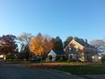
The surrounding neighborhood
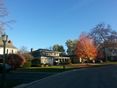
More of the neighborhood


