2014-12-19 47 -117
| Fri 19 Dec 2014 in Spokane: 47.6897705, -117.4286453 geohashing.info google osm bing/os kml crox |
Location
A house on a Spokane hillside, near Garland and Monroe
Participants
Expedition
The Seattle point was only accessible to fishes, so I headed east for this geohash. Well, okay, I had business in Spokane as well, but it was a 280 mile drive to the hash point.
Initial google maps aerial photo showed it to be beside the house. I parked in the driveway and snapped a shot, then tried the approach. Turns out the GPS put me 2m distant and within error range at the front corner of the house, so I snapped another picture of me and headed out for business.
This bluff overlooks downtown Spokane proper, and is probably a sandbank remnant of the Glacial Lake Missoula floods that tore down the river valley. Strangely it hasn't been developed at it would have been in Seattle... but then again, there are empty businesses everywhere you look. Not the strongest economy right now.
Saturday and Sunday points aren't terribly reachable, but I'll be up for a geohash Monday before I leave.
Photos
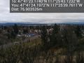
The view from atop the bluff @47.6901,-117.4277


Achievements
Thomcat earned the Last man standing achievement
|