2015-01-31 42 -86

| Sat 31 Jan 2015 in 42,-86: 42.7737610, -86.0676229 geohashing.info google osm bing/os kml crox |
Location
grassy area in front of a garage, Holland, MI, USA
Participants
Expedition
We had driven over to Holland to make a purchase at a particular store which was about 1 km from the hashpoint. The satmap showed the point just in front of a small building that was shaped like a house but had a concrete driveway apron all along its front, so I suspected it was a garage or something. We inspected it from the driveway of a big manufacturing plant just to the west and concluded it was not a private house, so we decided to return to the main road and come down the long garage driveway. However, as we turned into that one-lane approach drive, it became clear that it was an extension of a private driveway to a house nearer the road. To make matters worse, a pickup truck turned in just behind us, so it seemed likely that not only were we now on private property, but the property owner was following us in his truck.
We drove the quarter-mile down the single lane (it was too narrow to turn around anyway), and the truck did not follow, so we figured he had stopped at the house. At the end of the driveway I got out, quickly walked the eight steps to the hashpoint, took a picture of the car in front of the garage, and THOUGHT I took a proof-screenshot; the distance-value had been green nearly since I left the concrete, and I saw something like 0.8m flash by as I turned to take the car photo. I was in a hurry at this point and headed back to the car, since there seemed to be some danger that Susanne would drive off and leave me if I took very long. It turns out I did not get a screenshot, so the only proof I have is a photo taken from the hashpoint east toward the garage.
As we drove back along the lane we saw that the pickup was now in the lane, facing us, and blocking our way out. As we approached he backed up into the house driveway, letting us pass, and looked at us quizzically as we went by. I smiled and waved, trying to give an impression of carefree navigational helplessness.
I had thought this would be a Frozen Hash, but station KMIHOLLA29, about half a mile east, shows the temperature just above freezing at 1 pm when we were there.
After this little geohashing adventure we drove out to the (Lake Michigan) shore. The channel into Holland Harbor was full of loose ice, and there were interesting-looking ice formations along the shore and on the jetties.
Since this was in Holland, MI, USA, and I can think of at least one other place sometimes called Holland that contains some geohashers, I think I'll join the current trend and issue a Tale of Two Hashes challenge. JwB? CO2? A subset of the Netherlands is still called Holland, right? And, of course, Wikipedia shows a couple dozen places called Holland, some close to other active geohashers. Have at it, folks. I've put up a picture of the Holland Harbor Light along with its historical marker, to add authenticity to the challenge, though this same-day shot was taken several miles away from the hashpoint.
Photos
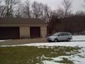
Shot to east from hashpoint. Susanne is in the car, Rebekah (not in picture) is next to me.
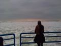
Rebekah checking out the lake, a few miles NW of hashpoint.
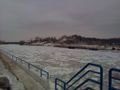
Shot to southeast from harbor mouth, looking along channel toward the harbor in Lake Macatawa (a drowned river mouth lake that empties into Lake Michigan). The big house overlooking the channel belongs to the DeVos family; their patriarch was one of the founders of Amway.


Achievements
Mcbaneg (talk) issued a challenge for the Tale of Two Hashes achievement
|