2015-03-02 63 28
| Mon 2 Mar 2015 in 63,28: 63.8833813, 28.4709460 geohashing.info google osm bing/os kml crox |
Location
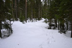
In Maanselkä. The point lies near the border of the municipalities Valtimo and Sotkamo, barely at Sotkamo side. The terrain is forest.
Participants
Expedition
Me and my family were visiting Pastori for winter holiday. Although it's fun also to ski in the untamed wilderness of Pastori's neighborhood, this day we decided to spend in the nearby skiing center, Vuokatti. After a brisk skiing tour, an hour of swimming in the Vuokatti swimming hall and a great buffet meal, we turned back towards Pastori's place.
Halfway home there was, however, a hashpoint only a click sideways from the main road. All else were a bit tired/sleeping because of the above-mentioned activities, but I wanted to go check how difficult to reach the point actually was. And there was some luck! A small forest road going a bit nearer the hashpoint was freshly ploughed. Only 360 meters of harder going was to be expected. Since I was the only one of the party who had prepared for the hashpoint and taken proper snow-boots with me, I had to go alone. Pastori said actually happy he didn't have the right equipment with him - his stomach was so full of the buffet food he wouldn't have floated very well in the snow.
So I started my expedition. First 200 meters I used the roadbed. A couple of days ago there was a really hard ice crust on top of the snow, but a couple of days with temperature on +1 had softened that, and there was little hope of any buoyancy. My feet sank about 30 cm into the snow, almost to the bottom of the roadbed. The road was silent and everything was in the shades of white and grey. Occasionally tracks of rabbits crossed mine. They seem to have sunken considerably less than me.
When the arrow of the GPS pointed straight to the side I turned for the forest. About 140 meters to go. When entering the forest the I immediately noticed that the consistency of the snow was no longer as uniform as in the road. With one step I would sink only 20 cm, with the next up to my crotch. Should have taken the snow shoes, they would have been the best choice for these snow conditions. Well, there was too little left to turn back now, so I just continued on trudging.
Soon I was at the hashpoint. A very normal-looking patch of forest covered with lots of snow. I took a couple of pictures for proof and started to retrace my own steps back. That made going a little bit easier, but not much. However, the return journey felt shorter and soon I was back at the car, tired but happy. A nice first hashpoint of the year!
Additional photos
Achievements
Tilley earned the Land geohash achievement
|


