2015-04-06 52 6
| Mon 6 Apr 2015 in 52,6: 52.9859730, 6.9993458 geohashing.info google osm bing/os kml crox |
Location
The Vledderbos forest, immediately east of Stadskanaal, Netherlands.
Participants
Plans
This would be an easy one. The coordinates are on a road in the forest, publicly accessible, parking spot nearby. Piece of cake.
Expedition
To challenge myself (it would otherwise have been too easy), I deliberately only viewed the road map once before departure, and drive my car about 230 km without any aid. Only about half a kilometer before the hash, the road was shut because of a sports event, but I could get around that obstacle.
The only real setback was upon reaching the hash. I used my phone as GPS device, and took a separate camera to photograph my phone's screen as proof of location. However, the second camera failed to operate (sounds like I blame the device, but an empty battery is obviously a result of poor planning). Therefore, I can now only bring circumstantial evidence of location without any proof of date.
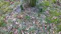
To validate that I was actually standing next to the right tree, do review the coordinates on an aerial photo to see that the right tree is the ninth one, counting from a crossing path in the north.
Tracklog
Photos
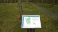
A map of the Vledderbos on the way in. Note the "U staat hier" ("You are here") with red arrow on the bottom of the map.
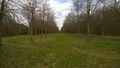
It should be somewhere along this road.
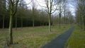
You can actually barely see the crossing path, but I'm standing next to the ninth tree here.
Now if only someone else found this after me, and could take a photo that does include proof of date and location.


Achievements
Blauwe BIC achieved level 1 of the Minesweeper Geohash achievement
|