2015-04-16 39 -89
| Thu 16 Apr 2015 in 39,-89: 39.9329228, -89.8361686 geohashing.info google osm bing/os kml crox |
Location
In a farm field just off Route 97
Participants
Plans
Bike there, targeting arrival at noon
Expedition
What a fantastic day this was for geohashing! I knew when I woke up it would be beautiful out, and a bike hash would be very pleasant. Temperatures in the low 70s, almost no wind at all, mostly cloudy, it was the perfect setup. And finally a point within 20 miles of home!
As I packed my gear together, I hesitated a bit, waiting an extra 30 minutes to let things warm up outside a bit more. I shouldn't have! Within a few minutes of setting off just before 11am, I got a message from work. They needed me in at 2pm instead of 6pm like I was scheduled. I briefly considered calling off the expedition. Google maps was estimating an hour and a half each way, which would get me home right at 2 o'clock.
However, I know from past rides that Google estimates bike speeds to average around 12mph. If I really pushed myself and didn't stop to rest, I felt I could save some time and make it back with enough to spare to change and head in to work. Que the most intense bike ride of my life!
As I headed west, I traversed a roller coaster like series of hills that had my legs screaming. I knew I couldn't stop to rest, or even slow down really, so I pressed on, heart pounding and lungs gasping. Luckily for me, most of Illinois is very, very flat, and so I was able to cruise around 13-14mph without much effort to let my legs rest a bit. But knowing that time was not on my side, I raced as fast as I could down hills, knowing that when I climbed the next one I would be traveling slowly again to recover. As I got within 3 or 4 miles of the point, I encountered a road unlike any other I had ridden a bicycle on. The pavement was cracked and cobbled, large amounts of gravel and loose asphalt were all around, and in places was washboarded so badly I thought it might shake my teeth out. And it was also on the steepest hill of the ride, where I easily hit 35mph on the way down. The adjectives used to describe riding on this road are terrifying, nerve racking, and extremely exciting. I really felt like I accomplished something significant just surviving that road and making it to Route 97.
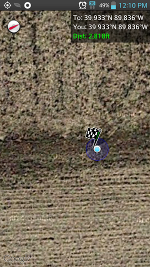
As I pulled alongside the field in which lay the hash point, I stopped to take a drink, and ready Geohash Droid and my camera. There was a fair amount of traffic going past, and farmers working other fields within eye sight, so I was genuinely expecting someone to stop and ask what I was doing.
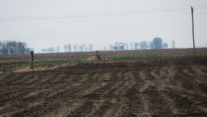
The field I was interested in, however, was empty, and a treeline blocked line of sight to the buildings of it's owner. They had recently plowed/cut up the surface, but had clearly not planted anything yet, so I hiked along the edge of the field until I reached the point. Success!
I took a quick photo with Collin at the point, and a heavily zoomed in photo of my bike in the distance, and made my way back. There was no time for more photos, and the longer I stayed in the field, the more suspicious people were likely to become. Since I was getting hot, my t-shirt and gym shorts came off and went in my bag, and I began the ride home in just my bike shorts, which are weird and I am still getting used to. I have no idea if I had a small tailwind, or if the break from riding revived my legs, but I made fantastic time on the way home. Each seemingly impossible hill was summited, even if it was done at 8mph, and between hills I cruised above my usual speed of 14mph. By the time I reached home it was 1:35. I had cut 10 minutes off Google's estimation on the way out and 15 on the way back.
After laying down to rest and having a drink and a snack, I was on my way to work, where I spent several hours moving commercial-grade freezers around. To describe myself as "sore" afterwards would be a colossal understatement.
Tracklog
https://www.strava.com/activities/286689946
Achievements
Mystrsyko earned the Land geohash achievement
|
Mystrsyko earned the Bicycle geohash achievement
|


