2015-04-24 41 -73
| Fri 24 Apr 2015 in 41,-73: 41.0612694, -73.9483724 geohashing.info google osm bing/os kml crox |
Location
In the parking lot of Starlight Limousine Service in Blauvelt, New York
Participants
Plans
This morning I biked from my home in Manhattan to work in Rockland County (about 27 km), for the very first time since starting this job three months ago (my employer had organized the riding for Earth Day.) Then at 2pm I finally got a chance to check geohashing.info ... and where should today's hash be but 7.3 km from work, in a clearly public parking lot off a main road! And with bike-friendly roads or bike paths most of the way there. I would never normally have a chance to get such a hash, since on all other days I'd taken the shuttle bus to work. Clearly the universe was asking me to go for it.
However, I did not want to bike all the way home afterward (food options are slim up here, plus I had stuff to do in the city) so I really needed to catch the last bus home at 6pm. I figured I'd leave work at 4:45pm and that would be plenty of time for the 16 km or so.
Expedition
However, time slipped away and I didn't even leave my office until after 4:50... around when I posted
- Going for it now... I happen to be 7km away with a bike! -- OtherJack (talk) @41.0040,-73.9056 16:50, 24 April 2015 (EDT)
So by the time I'd gotten my bike from the basement and set off, it was already 4:55. This was not nearly as comfortable as leaving at 4:45. I figured the ride back would take considerably longer than the ride down, since my work is on top of a >100m hill but the hashpoint was down in the valley... so I needed to reach the hash by 5:20 to be on pace (25 minutes down, 40 back up.) I rode hard.
At first I made good progress with the downhill, but there was a stiff W/NW headwind. Once I was in the valley by Sparkill, the going got very slow with the wind and I started to freak out a little. It didn't help that a portion of the bike trail marked by Google as paved was unpaved... and that the trail didn't have any access ramp to route 303, forcing me to overshoot by a few hundred meters. By the time I finally got on route 303 it was already 5:13, and the wind was screaming (and the highway was busy with cars.)
At 5:20 I still hadn't arrived so I seriously thought about turning back to catch the bus. But I was so close... so close! So I figured I'd risk it and press on. After what seemed like an eternity of forcing my bike into the wind, I finally saw Spruce St and then after a little climb Hickory St, which meant the hash parking lot. I rolled in, happy to achieve the hash at least. But what time was it? 5:23. OK, not doomed, but still very risky. After a quick breather and photos, I posted
- Made it! Pic upload not working but see coords... -- OtherJack (talk) @41.0613,-73.9484 17:26, 24 April 2015 (EDT)
and took off at 5:27. I consoled myself that the outbound and return times would actually be more equal, because the effects of the wind and the hill would cancel (and because I'd learned from my routing mistakes.) I'd made it down in 28 minutes and now had 33 minutes to make it back, which seemed possible.
And indeed it was a super amazing fun tailwind... I flew down 303 and 340 at something like 3x my outbound speed (avoiding the problematic bike trail), and was in Sparkill by 5:35. But the climbing part was really tough and at the base of the final hill it was already 5:49. Was 11 minutes long enough? I climbed hard up the little country road, and thankfully it was plenty of time... I arrived at the shuttle bus at 5:55. A bit too close for comfort though.
It was only when preparing this writeup that I realized (with the help of the Current events page) that this expedition qualified for Last geohasher standing!!! I have always wanted to win this ribbon, but rarely hash on weekdays so my chances have been slim. Actually, it's a good thing I wasn't aware of this during the ride, because I might have turned back at 5:20 and not gotten the hash (you win that ribbon just for mounting the expedition, you don't even need to reach the point...)
Photos
The scenery on this ride was amazing... big hills and valleys covered with hardwoods in spring bloom... but there are zero pictures of it. I guess that's what happens when you bike hash while racing against a deadline. Not the greatest way to hash, but effective.
Also, I don't know how to take a screenshot of my phone, so my proof is just the above post using geohashdroid stamped with the correct coordinates.
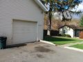
Geohash lot looking Northeast
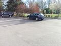
Geohash lot looking Southwest (towards Route 303). I did not see any limousines though
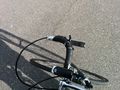
My speedy mount


Achievements
OtherJack earned the Last geohasher standing achievement
|
OtherJack earned the Bicycle geohash achievement
|
(finally, my first since moving to New York!)