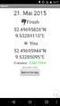
2015-05-21 52 9
| Thu 21 May 2015 in Hannover: 52.4969583, 9.5328411 geohashing.info google osm bing/os kml crox |
Location
The Geohash is located on a field of rye in Otternhagen.
Participants
Plans
It's Geohashing Day, and since I'm probably not avaiable for geohashing on Mouse Over Day, I'll be celebrating on the actual date. My plan includes taking tram 5 to Stöcken, from there bus 490 will bring me close to the hash.
Expedition
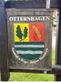
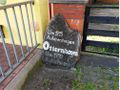
The algorithm took me to Otternhagen, which first was mentioned under the name Auterenhagen in 1215 and is named after the river Auter. The Geohash was located close to the Alte Auter (old Auter), a tributary of the Auter.
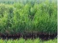
I first walked a path to it's end where it crossed the Alte Auter. The hash was on the left side of the stream, but I decided to walk on the right side because it looked easier to walk. Finally, I leaped over the Alte Auter and had to walk ten meters into the field of rye, where I did my best not to harm the plants. Since I didn't expect anyone else to come and 16:00 had already passed for a few minutes, I left the place after taking pictures.
Photos
Proof
Otternhagen
Otternhagen throughout the years
The Alte Auter
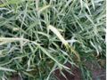
The Geohash
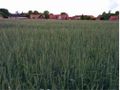
Landscape
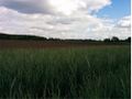
Landscape
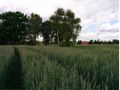
Landscape


Achievements
Fippe earned the 2015 Geohashing Day achievement
|
Fippe earned the Public transport geohash achievement
|
Fippe earned the Land geohash achievement
|