2015-05-28 39 -89
| Thu 28 May 2015 in 39,-89: 39.8178974, -89.6972230 geohashing.info google osm bing/os kml crox |
Location
Just off Veterans Parkway in Springfield.
Participants
Plans
We plan to bike there around 11am
Expedition
We were quite pleased to see a nearby point, so Dolphintreasure and I made plans to bike out for a quick and hopefully easy geohash. We left shortly before 11am, and once on the shoulder of Veterans Parkway, were soon in the vicinity of the hash. After laying our bikes in the tall grass (no random encounters luckily!), we cautiously made our way through the brush, wishing the whole way we had worn pants and not shorts. Luckily, it would seem that we did not encounter any poison ivy.
After reaching the bottom of the incline, we followed the almighty GPS signal across a small creek and under some trees to where the hash point lay. Success!
We snapped some quick photos and made our way back up to our bikes. Being on one side of a busy divided highway, we decided it was best to ride against the flow of traffic on the shoulder and take Jefferson home instead of retracing our steps. And just like that, a nice 30 minutes of bike riding and a geohash to go along with it!
After this, we coordinated with OtherJack on our second expedition of the day.
Tracklog
http://www.strava.com/activities/313586242
Photos
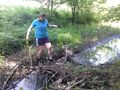
Dolphintreasure crossing the creek
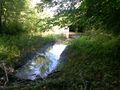
Hash looking north
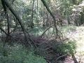
Hash looking south
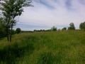
Traffic just up the embankment

Three happy geohashers!
Proof


Achievements
Mystrsyko & Dolphintreasure earned the Land geohash achievement
|
Mystrsyko & Dolphintreasure earned the Bicycle geohash achievement
|
Mystrsyko & Dolphintreasure earned the Multihash Achievement
|