2015-05-29 37 -122
| Fri 29 May 2015 in 37,-122: 37.8078270, -122.2518924 geohashing.info google osm bing/os kml crox |
Location
On a walking path by Lake Merritt in Oakland, California.
Participants
Plans
I was planning to run some errands in the city that morning, so when a geohash showed up I just had my brother drive the van home alone while I planned to return by public transportation.
Expedition
The errands went well, and I proceeded to travel by bus from Berkeley to the hashpoint in Oakland. I had never been to the lake before, and it was pleasant, if cool. There were many birds there, including mallards, Canada geese, an egret, and what I later determined to be a cormorant. An interpretive sign gave goose counts for each month of the year, with most months sitting in the 400s but June and July at about triple that population: late May is close enough to peak that the quantities I saw should be unsurprising.
I was a bit worried about the unexpectedly steep, artificial banks, as they meant that a small Google Earth satellite imagery offset could put the geohash in inaccessible water. But this was not a problem: Google Earth accurately located the hashpoint on the path itself, and I easily acquired the right coordinates. I then headed home by bus, BART, and (on one segment where there wasn't a bus at the right time) foot.
Photos

I have not yet mastered the art of sunny-day LCD photography, but today was cloudy.
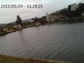
From the hashpoint, the north end of the east fork of the lake.


Achievements
Codae earned the Land geohash achievement
|