2015-06-04 49 8
| Thu 4 Jun 2015 in 49,8: 49.4368996, 8.3258459 geohashing.info google osm bing/os kml crox |
Location
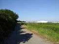
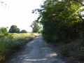
On a farm road between Dannstadt and Mutterstadt, next to the Autobahn A61.
Participants
I think, RecentlyChanged didn't come (but after his cool adventure yesterday, this is a rather boring one, so he better got some sleep).
RecentlyChanged: I did not attempt this one, I had a long night playing games online with my sister. I'm really happy that I did not attempt this one, see my plans on 2015-06-05 48 8.
Plans
- Planning to do this hash early in the morning, taking the motorbike. -- RecentlyChanged (talk) 16:04, 3 June 2015 (CEST)
Changed the plan, I hadn't slept yet. Maybe later. -- RecentlyChanged (talk) 22:43, 3 June 2015 (EDT)
Expedition
I had an appointment for rowing in the morning, and so I planned to go there by bike in the early afternoon. Surprisingly the rowing took much more time than expected, and we didn't come home before 5 pm. Well, it's summer, and so there's still plenty of time for a nice 40 KM bike trip :-)
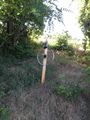
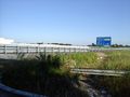
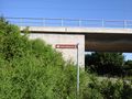
Except that I was already tired there wasn't much to tell about the trip to the hash. The point itself was on an asphaltic road that runs next to a ramp to the autobahn and was very easy to reach. I took some pictures, looked out for a sign from RC, but unless he had an bike accident, I didn't find any. So I left a mark myself and tried to continue my way, but just some 30 m further the road ends. The road shown on Open street map just doesn't exist anymore. So I had to go back on my way, take the bridge over the Autobahn and continue my way home on the other side of the Autobahn and my tron was gone.
On my way back home I came along a sign that lead to the find spot of the golden hat from Schifferstadt. As the tron wasn't possible anyway, it was an easy decision to make a little detour. It was nothing more than an information sign, but it's nice to know that people live around here for more than 3000 years (and they already wore hats).
Tracklog
42 KM by bike (komoot stated tracking a little bit to late)
Photos
40 m to the hash
1 m to the hash :-)

happy hasher
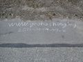
mark
view back
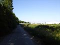
view forward
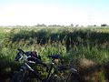
view to the bike
mark by an unhappy ninja?
there is no way (even if OSM said so)
this sign convinced me to make a detour
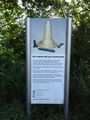
description of the golden hat (very spectacular)
and where it was found (not so spectacular)


Struggling with technique again. Will follow later.
Achievements
DODO earned the Land geohash achievement
|
DODO earned the Bicycle geohash achievement
|
DODO earned the OpenStreetMap achievement
|