2015-06-06 45 -122
| Sat 6 Jun 2015 in 45,-122: 45.3981129, -122.8971436 geohashing.info google osm bing/os kml crox |
Location
South bank of the Tualatin river, in what appears to be farmland inside or near to the Tualatin River National Wildlife Refuge.
Tualatin, Washington County, OR, USA.
Participants
Plans
Leave the house, drive a few minutes to the geohash. Ask permission to access it, since it appears to be on farmland. Wait for other hashers to show up.
Expedition
Left around 4 PM and underestimated the amount of time it would take for me to arrive. After a nice 25 minute drive through farm country, I reached what I thought would be the property owner's house.
This proved to be incorrect, however, as I was greeted with a big barred gate and a bunch of signs reading "Wildlife Refuge, No Entry". I backtracked to the next house over that I saw on satellite imagery, and spoke with the owners a bit.
They gave me permission to hike around on their land, but they were not sure who actually owned the parcel on which the geohash was situated. It could have been neighbors, or it could have been more National Wildlife Refuge land.
As such, not having permission to ultimately go where I needed to, I made one last attempt. I drove to the learning center and trailhead for the Wildlife refuge, to check and see if any of the trails they had would lead close to the geohash.
Unfortunately, there were actually very few trails, just a big 2 mile loop, none of which came even within a few miles of the geohash. I did get to check out the learning center and the flood plain at the Wildlife Refuge, which was nice.
Photos
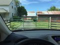
Gate blocking my first attempt to get permission/access.
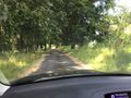
Secluded road to my second attempt to get permission/access.
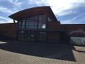
Learning Center


Achievements
- No trespassing