2015-07-03 43 -71

| Fri 3 Jul 2015 in 43,-71: 43.7285320, -71.6867188 geohashing.info google osm bing/os kml crox |
Location
bank of Glove Hollow Brook, Plymouth, NH, USA
Participants
Expedition
My 50th expedition!
This one was very close - less than 10 km - and this time there were other takers, including our two beginning drivers. So Katja drove out on interesting gravel roads over Bridgewater Mountain and Rebekah drove home on ordinary rural highways.
The hashpoint was about 50 m off the road, between the road and the brook. There was a slightly swampy area in the way but it wasn't bad enough to present a real barrier. The GPS was quite confused; the map showed the hashpoint clearly on the north side of the brook, but standing on the north bank it indicated we had to go another 10 m south. Rebekah actually carried it across the brook and tried the other side. She got somewhat smaller distance readings but the blue dot was clearly in the wrong place. We wandered around quite a bit. The whole area gave "within GPS error" readings. We're calling it good.
Just upstream, where the road crosses the brook, is the beginning of a trail to another waterfall. We didn't try it today but we'll come back later and explore. Two new waterfalls within a week: a nice side benefit of geohashing.
Update, 2015-07-09: today Susanne and I returned to the area and walked up the trail to the waterfall as promised. It's a lovely, easy walk, and there's a somewhat longer return trail that is also pleasant. I've added three more photos below to represent the overall success of the expedition.
Photos
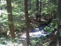
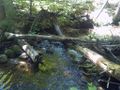
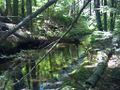
Glove Hollow Brook.
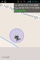
Best proof shot G. got on north side of brook.
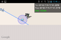
Best proof shot R. got on south side of brook.
Rebekah's return route from south side.
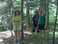
Rebekah, Susanne, Katja near hashpoint.
Shot to west from hashpoint.
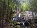
Rainbow Falls in the Walter/Newton Natural Area, about half a mile from geohash parking spot.
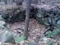
Old cellar just near parking area.
Blackberries!


