2015-07-12 49 8
| Sun 12 Jul 2015 in 49,8: 49.0325129, 8.5363002 geohashing.info google osm bing/os kml crox |
Contents
[hide]Location
Near Karlsruhe, south of Weingarten. On the map it looks like it is on the edge of a hilly forest. on a grassy area near some parking lots. It is right next to a 252 m high hill called "Hinterer Heuberg".
Participants
Plans
I want to do some biking tomorrow in the morning and will include that geohash in my tour. Maybe I will ride to Blankenloch first, where a friend participates in a triathlon, and go visit that hash afterwards.
Expedition
Waking up early and visiting the triathlon didn't work out as initially planned. First climbed the Turmberg with my bycicle, just because it is fun and then continued to go North West where the hash was supposed to be. Just knowing the general direction didn't help me as much as I hoped, the roads were winding a lot and I got lost more than needed and had to climb a lot of hills with my bycicle. At least that must have been good training. At a dead end. the owner of some horses let me through an electric fence, so that I would have to go back again. At least the way back home was faster :). I am a little bit disappointed of google maps. What looked like paved roads were actually former dirt tracks where I had to ride through tall grass. Still: I saw a lot, sweat a lot and the weather was really beautiful, was a nice Sunday.

On the Turmberg in Durlach which I climbed on the way. The ascent was not easy on my bike.
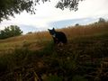
Local cat.
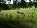
Local horses less than 1 km from the hash position. Got in a dead end and the owner of the horses turned off the electric fence to let me through the field. Not necessary for the hash, but I got lost and would have needed to take a large way around otherwise.

Finally made it. Internet and GPS weren't reliable at the hash position. Btw, those "white roads" are actually really bad dirt tracks.

Me at the hash position. Apple tree behind me.


