2015-07-15 43 -77

| Wed 15 Jul 2015 in 43,-77: 43.2600718, -77.6337817 geohashing.info google osm bing/os kml crox |
Location
thicket near a railroad embankment, Greece, NY, USA
Participants
Expedition
We had spent the night at a hotel just southwest of Rochester on our long drive home. Before we started out I checked the hashpoint and saw that it was well north of town, so I figured we wouldn't be making any expeditions that day. But, without any prompting from me, the discussion in the car turned to "why don't we take the scenic route along the lake, rather than going along the Thruway the whole way? We should just drive north along highway 390 until we hit the lakeshore north of town and then turn west." I responded, without a trace of ulterior motive, "Sure, sounds like a good idea." Then, once we were a good five miles along, I said "actually, today's hashpoint requires about a 2-mile detour to the east when we get to the lakeshore. How about we go pick that one up?"
We parked in the lot of a hockey rink. Susanne stayed with the getaway car but Katja and Rebekah and I headed for the hashpoint. We had an easy walk along a gravel road, then had to tromp through some weeds and across a very dodgy makeshift bridge over a boggy area before we reached the railroad embankment. A short easy walk along the railway service road and a 5-meter plunge through brush brought us to the hashpoint.
We returned to the car by a different, and poorly chosen, route: along a disused spur track that went north just west of the hashpoint. It was very weedy. We should have just walked along the main track service road eastward to the next road crossing. Future retro-hashers please take note.
Photos

Grins.
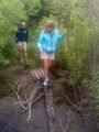
Crossing the bridge. That's a rotten railroad tie supported by a shipping pallet and a cinderblock. It wobbled.
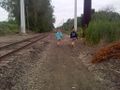
View to west along railroad.
Proof.


