2015-07-15 63 28
| Wed 15 Jul 2015 in 63,28: 63.8377639, 28.5473690 geohashing.info google osm bing/os kml crox |
Location
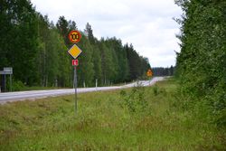
In Rumo, Valtimo. The point lies near the highway, in a forest.
Participants
Expedition
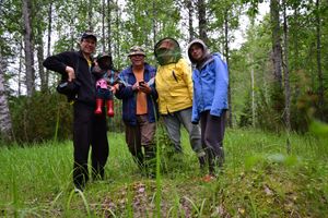
For today's hash, our expedition team was still large. Tilley and his family were visiting Pastori and The Wife, today for the last day.
This was a quick and easy expedition. After the breakfast we entered our hashvehicle, although there was a bit of a debate whether all 5 of us would fit in. But we did.
The hashpoint was about 12 km to the north. About half the distance we drove on the idyllic Rasimäki village road. There was unusually heavy traffic, three (3) cars came the other way. Then few kilometers on the highway, and there the point was, near the intersection to Roukkaja. We parked, surveyed the area a little to find the best way to approach the point, and then entered the forest.
For the first few meters, the bushes seemed thick, but then the forest opened up. There was even a nice clearance right at the hash-site. This eased Pastori's geodance a lot. Especially nice was, that the hashpoint was in the clearance, not in the junipers, that surrounded the clearing in large numbers. Quite a beautiful place, although the mosquitos hindered a bit the joy of admiring the surroundings. We quickly took a couple of photos, and left.
Note also, that Pastori got a record in terms of how near to the hashpoint he could get: only 0,095 meters! Splendid!
Trip statistics: driving 24 km. Walking 150 m.
Additional photos
Achievements
Tilley, Pastori & co earned the Land geohash achievement
|


