2015-08-02 48 10
| Sun 2 Aug 2015 in 48,10: 48.0012012, 10.7057050 geohashing.info google osm bing/os kml crox |
Contents
[hide]Location
The geohash is on the edge of a corn field near Buchloe.
Who Went
- TheOneRing - by public transport.
The Expedition
TheOneRing
From the map, this trip looked quite nice: outside of the city, surrounded by fields. At home, the weather was not very promising as it was raining softly. But when I arrived at Buchloe, it was dry and the Sun came out closer to the geohash.
The train to Buchloe was not in time, each trains on this route was not. There might have been some technical problems, but as long as I was not in a hurry, I could stand delays of 10 to 20 minutes.
From the train station in Buchloe, the way was parallel to the street on a combined pedestrian/bicycle path. Approx. 1km from the geohash, this path ended and I walked on the street. I already passes corn fields, which were not harvested yet. May still take a while, the corncobs did not look ripe.
Already from the map, one could see that the geohash was om a farm track or on the edge of a field; it was the latter. I reached a distance below 10m, but the measure jumped back and forth, so the point is my best guess. I took the usual photograph and walked back.
I looked for a cafe in Buchloe, but none was open apart from restaurants. Finally, I took a train back home (again 10min late, but well).
Photos
TheOneRing
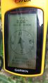
Coordinates reached, at least roughly
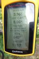
Some more information
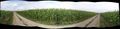
Panoramic view over the geohash, marked by my rucksack

The hasher

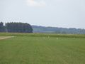
Panoramic view over some corn fields
Some egrets on a meadow


Achievements
TheOneRing earned the Land geohash achievement
|
TheOneRing earned the Public transport geohash achievement
|