2015-09-20 32 -96
| Sun 20 Sep 2015 in 32,-96: 32.8488893, -96.9247735 geohashing.info google osm bing/os kml crox |
Location
In a nature area between the University of Dallas and Highway 114.
Participants
Plans
I had some work to take care of around Inwood Road, and I wanted to visit the local temple afterwards, so I decided to squeeze this trip in the middle.
Expedition
It's been about 18 months since I've geohashed. I was reflecting on why exactly I had left hashing for so long. When I started this activity in 2012, I was doing it as an escape to a life which I thought was directionless. As things started to look up for me in late 2013, I felt I no longer needed the escape, so I gradually stopped checking the coordinate calculator.
Now I've moved out to Dallas for graduate school. Right as I moved, some of the stereotypes that Californians have about Texans came out in full force.[[1]][[2]][[3]]
I felt like an outsider, and wanted to find a way to feel comfortable in my new home. I gradually started to check the coordinate calculator more.
On Friday, I realized that I could get to the Sunday coordinates very easily. After taking care of things near Inwood and I-35, I decided to head over to the hashpoint. It was a very easy drive, I just had to take 35E North (I don't understand the naming either) and exit on 183 towards Fort Worth.
I drove around the neighborhood to get a feeling of what it was like. There was a private high school and college, some industrial buildings, and a very nice looking housing development in the immediate vicinity. I decided to park in one of the parking lots of the University of Dallas.
The campus looked very nice, with freshly manicured lawns, nice but boxy dorms, big sports fields, and new cars in the student parking lots. It appears to be a religious school, which means that there are likely no guns (the same cannot be said for public universities in Texas)[[4]].
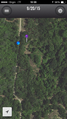
I walked around the fields before realizing that the hashpoint was in a stretch of undeveloped land behind the baseball diamond. After confirming via the U of Dallas website that I was still on university land, I set off on a dirt trail that went from the baseball field to (apparently) a road that leads to the frontage road of Highway 114.
After a short walk through the dirt path, I got as close as I could to the hashpoint. According to the map, I was close enough that I think I can call this a successful hash!
I look forward to doing more hashes and getting to know the cool neighborhoods of Dallas. It was a very helpful experience for me.
Photos
More pictures will come when I don't have to be up in 6 hours.

At the hash!
Proof of where I am.


Achievements
- Land Geohash