2015-10-24 49 -123
| Sat 24 Oct 2015 in 49,-123: 49.3388878, -123.0897548 geohashing.info google osm bing/os kml crox |
Location
On a street in North Vancouver, near the north end of the Mosquito Creek trail.
Participants
Plans
Walk up the Mosquito Creek trail, then walk back down it. If nobody joins me I might run it instead. It looks to be about an hour's walk to the hashpoint from the Seabus Terminal.
Expedition
The simplest execution of a geohash... I programmed the coordinates into my running GPS, then Sophie and I went for a run up Mosquito Creek. Between the navigation arrow and my memory of what the map looked like, I ran directly to the point then chalked the pavement and took a couple of pictures, after which I ran back to the park and a little further upstream before turning around and running home.
Photos
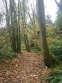
Heading up Mosquito Creek park
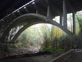
and under the highway bridge
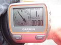
to the hashpoint,
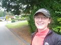
a silly grin,
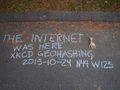
and some chalk marks.
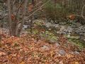
Then another picture of the park on the way back down, just because I live in a beautiful area.


Achievements
Rhonda earned the Walk geohash Achievement
|