2015-11-15 42 -72
| Sun 15 Nov 2015 in 42,-72: 42.7606843, -72.6327538 geohashing.info google osm bing/os kml crox |
Location
Wooded hillside just north of Sweet Pond State Park, Guilford, VT
Participants
Plans
Will probably try in early afternoon, making approach along state-park trail from public parking area at southwest end of (currently drained) Sweet Pond. Best-guess ETA 2 pm.
Expedition
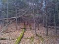
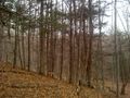
Made it, though not at 2 pm. My engagement earlier in the day lasted a little longer than expected (very pleasantly) and I didn't start the expedition until 2:08. Arrived at state park trailhead 3:30, left trail and headed into forest about 3:45 with 400 m to go, arrived at hashpoint 3:55. Open, easily navigable mixed conifer-hardwood forest with occasional tiny creeks or muddy patches under the leaves as the only barriers.
Photos
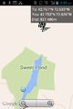
Screenshot shortly after leaving car, defining task.
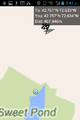
Screenshot at departure point from state park trail...
into this scenery.
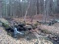
Typical stone wall from New England woods, crossing brook.

Proof.
View to north from HP.

Grin.


