2015-11-22 49 8
| Sun 22 Nov 2015 in 49,8: 49.4942502, 8.7563055 geohashing.info google osm bing/os kml crox |
Location
Between field and forrest near Lampenhain in the Odenwald.
Participants
Plans
I have to get up early tomorrow morning because the lady has to go to work. So I'll try to catch the train to Heidelberg at 9:02, ride to Heidelberg and walk to the hash. Afterwards I'd like to continue the walk to Weinheim and drive back home by train. If everything walks like planned, I'll be at the hash around 1 pm. If I should miss the train I probably go there by bike (if it isn't raining).
Expedition
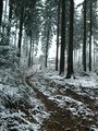
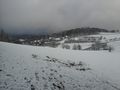
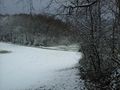
Well, the start worked as planned (and so does pretty much the rest of the tour). I left home a little late but walked fast enough to be at the station at 8:57. Enough time to buy a ticket.The train was in time and so I started walking in Heidelberg at 9:45.Unfortunately my tablet didn't get any gps-reception, and I hadn't loaded the tour on my garmin, so I had to use the tablet map traditionally. For heavens sake I'm old enough to have learned this old cultural technique.To my surprise all the hills around Heidelberg where white, and I was very delighted about that. I hadn't expected a walk in the snow. From Heidelberg I walked along the Philosophneweg (philosophers way) with his great view above the town and the castle. Then I had to walk higher and higher up to the Weißer Stein (white stone) the highest mountain around here with 548m (Heidelberg main station is at 150m). It was an unexpected winter wonder land up here and I enjoyed the walk so much. Now I had some ups and downs but stayed around a height of 500m. The snow was 5 cm high up here and my progress was fast.
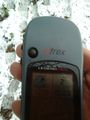
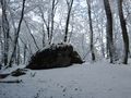
Suddenly, I had just 200 or 300 m to the hash, the tablet started to speak. After 3 hours of walking it has gained gps reception. Maybe it was the cloudy weather or the snow, the valley and the forest that it doesn't like. Supported by two tools it was easy to locate the hash, but not so easy to gain a proof; some wind came up and blew the snow from the near trees, so it was hard to take any pictures as the tablet got wet and wetter. Then I started to build a snowman - at least a little one (around 1m). He got my walking sticks as arms and a face made of leaves I found under the snow. But he fell over and broke apart before I could photograph him.
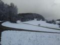
A little - only a little - frustrated I continued my way at 1 pm as I still had 13 kilometers to go. Half an hour later I reached the Eichelberg, the second highest point for today with 526m and the snow was absolutely great up here. After that came a very steep decrease and it was really difficult to walk down especially with all the snow. And then the winter wonder land was over and it had only some white color here and there. I needed two more hours to reach Weinheim where I paused for some cake and some tea. Then I continued to the station for my ride home. My train was six minutes late what was bad as I had five minutes to change in Mannheim-Friedrichdfeld, but the other train waited for us. After another change of trains in Ludwigshafen I reached Speyer again at 17:13 after 28 KM of walking (plus 1 KM to and from the station each) and 84 kilometers in trains. A great day.
Tracklog
28 KM walking. and 84 KM by train
Photos
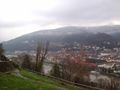
Heidelberg, the castle and the snowy hills
the white stone (548m)
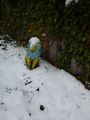
he must be cold
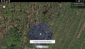
Here started the tablet to speak. The hash lies at the second group of trees
proof
another proof
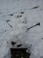
the remainings of the fallen snowman
view to the south (and the poor snowman again)
view to the east

view to the hasher
winter wonder land
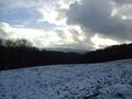
view back to the white stone (the tower in the background)
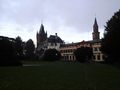
Weinheim castle

every good walk needs a good cake


Achievements
DODO earned the Land geohash achievement
|
DODO earned the Public transport geohash achievement
|
Is it true that DODO earned the snowman geohash?
|