2015-11-25 60 5
| Wed 25 Nov 2015 in Bergen: 60.2792589, 5.5843808 geohashing.info google osm bing/os kml crox |
I'd like to start by thanking GoreTex and the Norwegian Turing Association for making this hash possible.
Contents
[hide]Location
Well... 500m off the road, not too far from home? I'd like to define a new unit of measurement here and that is 1 hash-meter, or for those in the US, a "hash-mile". I think you all know what I mean.
Participants
- That creepy feeling you get off the trail when you realise you're deep into a hunting area wearing all black.
Expedition
Never learning from my mistakes (visions of orienteering at highschool), I park (11:45 am) at the closest point to the hash on the road and try to get directly to it. After clambering up for what seems quite a while I look at the phone - then down - and realise this is NOT happening. (see pics). Screw you contour lines - mother nature's bitch!
Trying not to injure myself on the way down, I go back to the car (12:15 pm) but drive to a sign a few hundred meters down (south-west) the road which points to a trail. Unfortunately the trail is not actually marked on the website [1] so I don't know where it goes, but it is marked by streamers hung on trees along the way. Refusing to be MNB, I decide to take the trail to get higher and then see how it goes from there.
Needless to say, this was not a quick hash! I did not take too many screenshots along the way but have drawn some sort of approximation for the trip. I took the trail towards "Strandfjellet" which I am yet to find on a map. It started I am not sure how close to the end of this trail I reached but after reaching the ridge/high point, I thought it best to focus on the hash given that I had no idea where the end of the trail was and the limited daylight hours. I did get to an obligatory high point pile of stones and a hunting cabin so I may have been quite close. (13:45 pm). From the start of the trail it was probably about 1 km distance and 350 m elevation, from a starting point of 75 m at the road.
I should mention at this point that the trail was pretty wet, as were my gloves. I was covered in wet plastic and Goretex and praying they would be sufficient for what I was about to do.
Unfortunately I did not take a screen capture at the top of the trail, but I was near to the top end of the most eastern branch of the stream and approximately 550 m from the hash but on a much closer elevation.
From there it took me just over half an hour of bush-bashing to cover the distance to the hashpoint and then some more circular bashing to zero in. It seemed like longer. By this stage I had passed a camouflaged treetop hide and was becoming aware of the fact I was walking around along in a hunting area wearing all black. I unzipped my jacked a for a while thinking a flash of aquamarine might help but then it started to snow. I was also aware that I had to make it down the steep hill by either retracing by steps all the way back or taking a gamble and trying to head straight down and intersect the trail to get down before dark.
By my calculations, it takes at least 4 times longer to cover such a distance than on normal ground. 15 minutes and only 75 meters!? And even worse going up a slope even on a trail. Hence my new term: hash-meters.
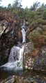
Although slightly grey and "damp", there were some nice open areas to gain some ground and I came across the two lakes that could be seen on the map which was I was pretty excited about. That was also when the snow started which was the first for the winter so also a little exciting despite it melting right away.
As you can imagine, I was absolutely relieved and satisfied to find that my efforts resulted in a successful hash!!
After taking a few pics and screen shots I proceeded with my plan: "down, careful, stay on a track" in a diagonally downwards way back towards the trail (knowing already what was directly down towards the road - sheer ROCKS!). I was very lucky to intersect the trail again at one of the stream-crossings and ended up back to the car some time just after 15:15 pm, wet, happy, hungry and thirsty!
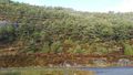
Looking up at the hash point from the road


Achievements
Phi-loci-raptor earned the One with Nature Geohash Achievement
|