2015-11-28 42 -79
| Sat 28 Nov 2015 in 42,-79: 42.5481804, -79.0620925 geohashing.info google osm bing/os kml crox |
Contents
[hide]Location
In the grass by the corner of Woodchuck Rd, on the edge of Seneca Nation Territory
Participants
Expedition
I had plans to help my sister set up her internet and it went poorly. The wireless router was not getting an IP address from the modem and I was getting ready to take a hammer to things. Needless to say, things took a lot longer than they should have. Getting done there, we went out for dinner for Korean which was nice.
I got home around sunset, but figured the hash wasn't too far away and I had some free time. I at least remembered a better flashlight this time. Getting to Irving, NY, I missed my last turn because the side streets were not well marked, so I had to find a place to turn around. Doing so, I turned on Woodchuck Rd and was glad to see wide shoulders on the road to park. I stopped about 100 feet from the corner and in front of the Seneca Nation signage so I could take a picture. They sound very threatening if you are thinking of trespassing on Seneca Nation lands.
Walking over to the hash, I was close to a telephone pole which I checked again for Posted signs(I didn't see any on Google Streetview earlier either). Satisfied there were none, I moseyed over about 20 feet on the grass to the hash, where I had to do a bit of a GPS dance to get it down to a reasonable reading. Getting my pictures, I went back to the car for my stupid grin picture and then headed for home.
On the way back, I saw the no-longer-quite-full moon trying to poke through the clouds but not much else of interest.
Photos
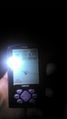
Made it.
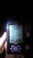
Accuracy.
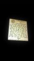
Seneca Nation warning sign.

Standard Stupid Grin.


Ribbons
This user earned the Land geohash achievement
|