2015-12-20 53 11
| Sun 20 Dec 2015 in 53,11: 53.9811163, 11.4269100 geohashing.info google osm bing/os kml crox |
Location
The hashpoint is located on a field among the reeds south-east of the village Weitendorf on the island Poel. A wet, swampy and muddy area.
Participants
Expedition
Everything startet because of christmas. Like every year I visit my origin graticule to meet my family. So I was really surprised to find the location of today only roughly 2 km south-west form my home. I first planned to start geohashing with registration on the Wiki and everything in 2016, but this coincidence changed all plans.
The Preparation: So I was checking achivements, which ones were possible to fullfill. Ok, the "Land Geohash". The "Walk geohash" would be possible, too. Maybe the "No Batteries geohash"? As a participant of boy scouting it schould be possible to determine the final location by compass and cross bearing. openstreetmap, Bing maps and google maps show the location on a field near the shore, maybe among the reeds? Ok, tomorrow we will see. The last thing to do was finding some distinctive features for the cross bearing. Firstly the church steeple, but the second one? There are no features located in a useful angel. BUT openseamaps showes the buoys in the Kirchsee bay and their coordinates. So I calculated angels for the bearing, made a sketch for the buoys to count, and a sketch for the near sourroundings of the final location from the satellite images, because the printer doesn't work.
The actual Expedition: All planning happend on the 19th so an early start was possible. The expedition startet around 10 a.m. the weather was nice, not too cold, but definitely warmer than a december morning should be. The first part was along the road on the cycle path to the village Weitendorf. It's quiet, only single cars are on the road. Behind Weitendorf I entered the fields and the first reeds appeared: The first ditch, right shoe gets wet, moving on along the edge of the field. Next stop: the fence located a bit south of the hashpoint. The satellite images showed seven posts, then something looking like a path and two more posts and then the hashpoint is located about 20 m north. And there are reeds like I guessed from the satellite images, too. Maybe the cross bearing will not work? But first try to reach the hashpoint roughly. What looked like a path or something on the images was another ditch. A freshly dug out drainage ditch. So I can't blame mother nature for this. So I climbed over the fence to look for a better possibility to cross this dich more south. Nope. But among the reeds was something that looked like a wooden plank. So I got back over the fence and through the reeds. And there was the plank. An old slippery wooden plank over the dark muddy waters. On the other side: reeds and swampy grounds. The top of church steeple was visible but forget the buoys. So no cross bearing. Time to start the GPSr. The final hashpoint was about 10 metres away, so I placed a stone marker, took photos and went back home. Overall 4.26 km on foot to the hashpoint and back, but no "No batteries Achievement".

On the road to Weitendorf
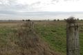
The southern fence
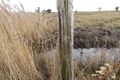
It's a ditch... Dead end?

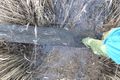
A wooden plank saves the day
bridge over muddy waters
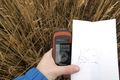
Hashpoint with GPSr and (now mostly useless) sketch

stupid grin and placed marker


Achievements
ZettS earned the Land geohash achievement
|
ZettS earned the Walk geohash Achievement
|