2016-01-30 42 -85
| Sat 30 Jan 2016 in 42,-85: 42.9269868, -85.5378281 geohashing.info google osm bing/os kml crox |
Location
In the rough of a golf course at Watermark Country Club, Cascade, MI
Participants
Expedition
After a successful Jan 1 start to the geohashing year, I had had three disappointments: accessible-looking and very interesting hashpoints at places a little too far away to justify for in-the-dark expeditions, and a trivially easy hashpoint within honorable-mention range of my office on a day when I didn't check the coordinates until I got home. Duh.
Today the point was just off the route to the supermarket. It was clearly on a golf course (often No Trespassing) but it was on a power line right-of-way and I thought it might be possible to get there that way.
My initial approach failed because the road I saw on the map turned out to go into a gated community that lies next to the golf course. The second attempt, from the north, succeeded; I was able to walk past the clubhouse and onto the golf-cart track, and there were no "Private", "No trespassing", or similar signs to block the way. It was a warmish day and about three-quarters of the track was even clear of snow and ice. Greens, fairways, and sand traps were starting to reappear too. The walk from clubhouse to hashpoint was about 750m, past very nice houses built remarkably close to the fairways.
I'm not a golfer, and don't own a golf ball, so I did not earn a Golf Geohash on my one previous golf-course expedition 2014-02-01 42 -85. Just a few meters along the path, though, a golf ball lay nestled in the snow. I picked it up and put it in my pocket. Once I got to the hashpoint, I held it up and let it fall. This does not get me the "truly awesome individual" version of the Golf Geohash, but it appears to meet the basic requirement.
Photos
Initial approach from the west...
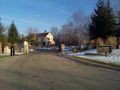
thwarted by gate and "Private Drive" sign.
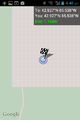
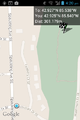
Proof.
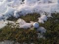
Golf ball dropped at hashpoint.


Achievements
Mcbaneg earned the Golf Geohash Achievement
|