2016-02-02 50 7
| Tue 2 Feb 2016 in Bonn: 50.8809662, 7.3227008 geohashing.info google osm bing/os kml crox |
Contents
[hide]Location
A wet meadow north of Seelscheid.
Participants
Expedition
32 km to the hash: I drove the B56 to Seelscheid. From the center a couple of narrow streets with only one lane leads to the Frauenstraße. It is the most northern road of the town; further north there are only forests and meadows - for about a kilometer, then there is already the village Hohn (what means mockery, by the way, but I'm sure that's only coincidentally). When I parked the car the distance to the hash was only about 250 m. I entered a path leading to the north. On the left hand there was a lonely house with lights in one room, on the right hand was a slope of 2 m behind a rivulet. At 40 m distance to the hash I had to leave the path for the hash was now directly in the east of my position. You can see the exact position in http://www.openstreetmap.org/?mlat=50.880966&mlon=7.322701#map=16/50.8816/7.3213
I tried the slope but i was not only very wet but full of thorns! I remembered that I had seen a possible passage at the beginning of the path and went back. About 10 m from the street was a gap in the bushes, probably to let a tractor drive eastward. After I had crossed it, I saw a far plain of meadows, stretching to the dark horizon. And I felt that it was very wet here (it had rained the day before... and the day before). At least the flatness helped to perform the geowalk quickly.
Standing inmidst the meadow, it was sheer impossible to take a picture of me with some surroundings for I had no tripod here. After some tries with my anorak on the ground as a base I used a tree at the edge of the meadow at least, hanging the camera on a small branch.
To keep the tradition of fast hashes, I ran the route back to my car. Midnight-jogging.
Photos

A meadow in darkness, far and wide
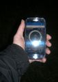
Compass proof

Standard proof
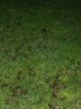
The grass is green, it's nearly midnight and it's nobody there
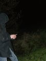
...except me, surely grinning


