2016-02-07 52 4
| Sun 7 Feb 2016 in 52,4: 52.5043244, 4.9370524 geohashing.info google osm bing/os kml crox |
Location
In a new residential area in Purmerend on the corner of the Helsinkihaven and the Vallettastraat
Participants
Plans
Go there somewhere in the afternoon, going by public transport, walking the last part.
Expedition
Woke up a bit past 9, so I decided I would take the ferry at 10. Had breakfast, packed my stuff and walked to the ferry. From the ferry I took the bus to the station and 2 trains later I found myself at one of the railway stations in Purmerend. Here I turned on my gps, or tried at least. After replacing the batteries I turned on the GPS and told it I wanted to walk to the hash. Some beeps later I arrived at the hash.
I started with taking some pictures. Played a bit around with different camera settings and decided to shoot a panorama. I didn't leave a mark, because the wall closest to the hash point was in such a terrible state that I was afraid the whole thing woud collapse if I tried to do anything there.
After this I walked to a different station. I went back to Den Helder, went to the supermarket for some stuff we forgot to buy yesterday and walked to the ferry. After the short trip with the ferry and walking a few minutes I found myself back home, 6 hours after I left home.
Photos
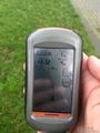
I was there

I was there
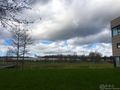
Highway on one side
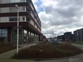
Houses on the other side
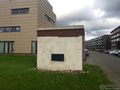
Doesn't look very solid


