2016-02-26 42 -78
| Fri 26 Feb 2016 in 42,-78: 42.6395631, -78.9986172 geohashing.info google osm bing/os kml crox |
Contents
[hide]Location
In the woods, East of Angola; between Rt 20 and Gowans Rd
Plans
Going to drive to the hash after work and then head into the city to meet my parents for a fish fry at a Firehall close to them. I should be able to park on the shoulder of Rt 20 and walk into the woods. The steet-view does not show any posted signs from 2013.
Participants
Expedition
When I arrived at the location to park, I saw a lot of frozen standing water in the woods and I thought this could be messy, but without posted signs, I had to at least try. I avoided most of the frozen puddles until I got to a wide section where the ice was not nearly thick enough to support me. Using fallen branches and a small log, I nearly made it across, but still got some water in my shoe. With a cold foot, I determined that I would get the hash and make this at least worth it.
Getting away from the more flooded areas, I noticed a lot of wild turkey tracks. The closer I got to the hash, the more there were, until I looked up and to my right where I saw the whole flock. There were probably 15 - 20 birds and they didn't seem too concerned by my presence so I was able to get a few pictures.
Finally, I made it to the hash without any other issues and got my pictures. The turkeys clearly beat me to the hash as they tore up quite a bit of an area next to it looking for food hidden in the leaves and snow.
I avoided the swampy area getting back to the car and drove to meet my parents for a delicious fish fry.
Photos
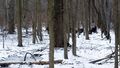
On the way to the hash, these guys kept an eye on me, but weren't really concerned.
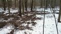
Right next to the hash, I could see they were foraging for food.
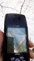
Made it.
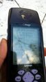
Accuracy.

The tree behind me makes it look like I have one of those puff-balls on my hat.


Ribbons
This user earned the Land geohash achievement
|