2016-04-06 62 24
| Wed 6 Apr 2016 in 62,24: 62.2058044, 24.9566613 geohashing.info google osm bing/os kml crox |
Location
In Lempaatsuo, Keuruu. The point lies in a swamp.
Participants
- Tilley
- Mrs. Tilley
- Our Daughter
Expedition

Spring has finally come to Keuruu as well, and the epic-winter-4WD-snowcrawling times are over. It's time for epic-spring-4WD-mudcrawling. Our car still has winter tires, or, as they actually are marked, M+S (Mud + Snow) tires, so let's not forget to test the performance of the tires in those latter conditions as well. To this today's hashpoint presented a good opportunity.
Actually it was only 3 km to the hashpoint from where we live. And still we took the car instead of bikes. Why? Because the road is so horribly muddy that the bikes would get absolutely clogged with mud, and most of the way would probably even be impossible to ride because of the soft surface. Fatbike would probably have been ok, but that we didn't have. Walking all the way would have been a little too exhausting, the mud is not quick to walk in, either.

So, in the afternoon, Mrs. Tilley picked Daughter up from daycare, I jumped aboard from our home where I had been telecommuting, and we proceeded towards the hashpoint. I had anticipated the road to be muddy, but OMG. The mudpools were so deep water splashed all the way up to the windshield when going over them, but it was not possible to drive very slowly because there were hills, too, and you had to have some momentum for those. The main tire tracks in the middle of the road where a bit harder, because the roadbed was still frozen, but if you strayed half a meter from the middle, the surface was super soft, and tires sank at least 5-10 cm instantly, and there was massive suction effect towards the side of the road. 4WD was needed indeed to get through, and the system was even pushed a bit too hard, judging from the smell of the clutch surfaces of the 4WD clutch. Well, the 4WD system has a built-in overheating warning, but that didn't activate, so I guess it's within design parameters. However, soon it was over and we were near the hashpoint at an intersection where we left the car.

So, now to the easy part. Walking 300 meters of forest/swamp to the point. The first part of the forest was easy, open young forest. There were not much snow anymore in the forest, 10-20 cm in here and there, and even clear patches a lot. The air was refreshingly moist, luckily the rain which had lasted the previous night had stopped. Halfway there we spotted some elk tracks and even droppings, which looked kind of fresh, but I think actually weren't, they were just preserved well in the frozen state and now recently unfrozen. Quickly we reached the edge of the swamp, with some ditches and a creek. From there on, Daughter had to be carried, the terrain was a bit demanding for her.

Soon we were at the hashpoint with excellent satellite reception, accuracy of 0,44 meters. A group pose, a look around, and then we started going back our own tracks. It was actually kind of necessary, because this kind of swamp forest is hard to navigate, there aren't many notable landmarks. Even the sun was deeply obscured by the clouds, not providing much navigational assistance. But following our tracks we made it back. Daughter wanted to climb some large rocks, after which we headed home. This time I kept it under 40 km/h to keep the 4WD clutch permanently engaged to go easy on the system. It was a bit easier to go more slowly, too, because the way home was downhill, while going the other way we had to drive uphill.

Additional photos
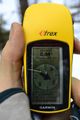
The GPS proof.

Achievements
Tilley&co earned the Land geohash achievement
|