2016-04-13 52 1
| Wed 13 Apr 2016 in Norwich, UK: 52.2950729, 1.4226536 geohashing.info google osm bing/os kml crox |
Location
In a field with a perimeter public footpath, south of Heveningham, Suffolk, UK.
Participants
Expedition - Fail
This was close to my route home after a walk with the Waveney Ramblers. Quite a large group of cheerful walkers took advantage of the first really warm day of the year. The trees were beginning to burst into leaf. I mentioned geohashing to one of the walking group. Most people react to geographical hash functions with a glazed stare but he said he'd look it up later. Perhaps 52, 1 will get another participant!
The hashpoint meadow on Google Earth looked empty and grassy. In reality it was divided into several horse paddocks with various sorts of gates and fencing, including electric. My no-damage, no-disturbance rules prevented me from reaching the destination but I got to within 40 metres.
Photos
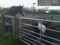
Horses @52.2948,1.4222

Foiled. @52.2948,1.4222
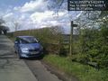
Footpath and Car @52.2941,1.4229
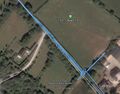
Google Earth Track


Achievements
Expeditions and Plans
| 2016-04-13 | ||
|---|---|---|
| Las Cruces, New Mexico | GPS Men | Chippewa Tr. in the Talavera section of Las Cruces, NM |
| Buffalo, New York | Pedalpusher | In a field by Railroad tracks in Ellicottville |
| Mannheim, Germany | DODO | A field between Berhausen and the Berghäuser Altrhein. |
| Kassel, Germany | GeorgDerReisende | The hash lay in the nature preservation area Dönche in Kassel. |
| Norwich, United Kingdom | Sourcerer | In a field with a perimeter public footpath, south of Heveningham, Suffolk,... |
Sourcerer's Expedition Links
2016-04-11 52 1 - 2016-04-13 52 1 - 2016-04-14 52 1 - KML file download of Sourcerer's expeditions for use with Google Earth.