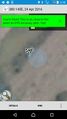
2016-04-24 -38 145

| Sun 24 Apr 2016 in -38,145: -38.1992157, 145.4737921 geohashing.info google osm bing/os kml crox |
Location
In between the main drains in Koo Wee Rup.
Participants
Plans
I was down at Philip Island all weekend and had my cycling gear with me, praying to the Geohashing gods to give me something close to home. Which they did - one in Clayton, which I frequently ride through, and one in Koo Wee Rup, which is literally on my route down to Philip Island.
No chance of getting to either of them on the weekend so I did it today (Monday 25th) - not sure if this counts but I did actually reach the hashpoint.
Expedition
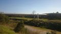
I scoped it on the satellite photo as being on the Koo Wee Rup bypass but what I thought were roads were actually the drainage channels coming out of Koo Wee Rup. I got to within 200m just on the road and decided that I could get closer. Took a detour to Railway Road which runs alongside the drain, then hopped out, onto the railway bridge and next to one of the channels.
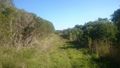
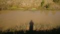
I walked the 150 odd metres to the hash only to discover it was on the other side of the channel, so I swore a lot and walked back to the railway bridge then jogged to the hashpoint, took my photos and jogged back to the car. In and out in about 15 minutes.
This is the first hash in a while I've actually been able to stand on so am disappointed I couldn't get there bang on the 24th. Coordinates reached, however!
Tracklog
Photos
Gottem!
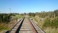
On the tracks
A few hundred metres away
Wrong side. Doh!
Back and there again.
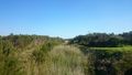
Looking back toward the hash
The point.


