2016-06-05 48 7
| Sun 5 Jun 2016 in 48,7: 48.0308000, 7.9252089 geohashing.info google osm bing/os kml crox |
Location
A field in the Föhrental, probably steep and used by cows.
Participants
Plans
Frizzy and Hijackal see that this one is about 5 km from their home and decide to go for it. Five minutes later, some friends call to say that the weather does not seem suitable for climbing. Being that sort of family, they are quickly convinced to go on "eine völlig sinnlose Wanderung" - a completely pointless hike.
Since there are some 500 m of altitude between us and the hash, the 5 km might take a while. If anyone is spontaneous, our ETA is about 13:15.
Expedition
The potential dragalongs arrive less than hour after the phone call, and the expedition begins. Everybody pretty much knows the way. At one point, a fence has been moved, and a farmowner informs the group that they are on the wrong side of the fence. Claiming that this was a hiking path in years past, the 'hashers are told "this path no longer exists, but if you'd like to follow it, it's right that way". At the Wildtalereck, the highest point on on the way to the 'hash, a huge chestnut tree provides shade for a rest. After going through most of the food, the group continues. Soon, the dragged-along child -- suffering from self-inflicted sleep deprivation -- declares it does not want to continue down towards the 'hash, having just realized it would need go back up the same way after reaching the hash. The group splits up: the dragalongs head down on side of the ridge towards home; Frizzy and Hijackal head down on the other side to the 'hash. As they reach the hash, raindrops fall and distant thunder rolls. Very quickly taking a single grinning selfie, they head home at a quickened pace. Luckily, they return home in nothing worse than a continuous drizzle that stays on the refreshing side of cool and does not turn into anything less pleasant.
Tracklog
Photos
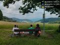
A nice break with some food... It's all downhill from here! @48.0315,7.9172

Yay! Now we just need to get back home before that thunderstorm gets here... @48.0310,7.9252

