2016-07-10 42 -78
| Sun 10 Jul 2016 in 42,-78: 42.5020188, -78.6925195 geohashing.info google osm bing/os kml crox |
Contents
[hide]Location
In a field next to the Walmart and Dollar Tree parking lots in Springville
Participants
Plans
My initial thought was this is just within my (current) limit of cycling and while I'm busy in the afternoon, I could definitely ride to this in the morning. Later on Friday, my sister called me asking if I wanted to ride with her around Allegany State Park in the morning. As this is literally on the way, I'll drive to this on my way to ASP and park in the Dollar Tree lot. It should be very easy to get to from the satellite pictures; it looks like it's about 30 meters into a sparse field that may be mowed on occasion.
Expedition
With the plans set, and bicycle packed in the car, I headed off to Allegany bright and early. Getting to Springville, I exited the 219 and made my way to the appropriate parking lot. Being early on Sunday, the lot was mostly empty as the stores were not yet open.
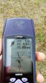
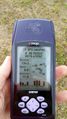
I walked out into the field and quickly got a reading on the hashpoint. I also noticed a number of Groundhogs (also known as 'Woodchucks'). The closest one hung out and I was able to take a picture of it. Getting the rest of the pictures, I walked back to the car. Getting one last picture of the hash-site, I continued on my way to Allegany.
Locating my sister at her friend's campsite, we hung out a bit before riding around the park on the 3 main park roads. It was over 2 small mountains(?) or really big hills anyway. So there was a lot of up with really long, fun downs. Returning to the beach parking lot, we had lunch and I bought an ice cream before heading for home.
Photos
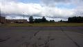
A view of the hash from the parked car.
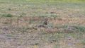
There were three Groundhogs at the hash; were they having a meetup too?
Made it.
Accuracy.
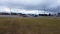
View East toward the hash-mobile.
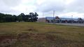
View North toward the Dollar Tree. You can almost make out two of the groundhogs in this picture.
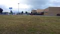
View South toward Walmart.
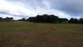
View West toward the 219.

Here I am.


Ribbons
This user earned the Land geohash achievement
|