2016-08-29 51 4
| Mon 29 Aug 2016 in 51,4: 51.9795553, 4.2558117 geohashing.info google osm bing/os kml crox |
Location
De Lier, Westland municipality, South Holland province.
Participants
Expedition
This was another close hash, at about 11 km from my house, in a village called De Lier. In modern Dutch this means either "The Winch" or "The Lyre", but its name is actually derived from the river Lee that flows through it. The Westland area (roughly the triangle between Rotterdam, The Hague and the coast) is traditionally known for its horticulture industry, and greenhouses filled with cucumbers, tomatoes and bell peppers are to be found everywhere. More recently it's also becoming part of the commuter belt of the large cities nearby, and new residential areas are popping up all over the place.
The hash seemed to be an easy one to try after work. According to OpenStreetMap it was located in a "construction area", so it might have ended up being on a building site or something. When I arrived there, it turned out to be in a large grassy field that looked like a vacant lot ready to be filled with more suburban housing. It was pretty easy to achieve a zero reading on the GPS.
Photos
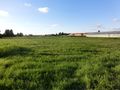
The field, wedged between greenhouses and modern housing developments. Very typical of the Westland area.
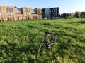
The hashbike, parked at the spot. Newly built houses in the background.
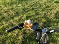
Lloyd posing at the hash.
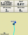
GPS proof.


Achievements
FelixTheCat (talk) earned the Bicycle geohash achievement
|