2016-09-11 50 6
| Sun 11 Sep 2016 in 50,6: 50.3236616, 6.6997710 geohashing.info google osm bing/os kml crox |
Location
In a forest near Hillesheim (Eifel).
Participants
Plans
After having a very nice class reunion yesterday I wanted to continue my hash tour that started the day before yesterday. The closest point was in the Frankfurt-graticule near Bad Ems, only 20 kilometers away. A perfect distance for a walk, but I had my bike with me, so what should I do all day long in Bad Ems. So I decided to conquer a new graticule and ride into the Eiffel. (By the way, I lived more than a third of my life in Cologne, and so this is somehow a home graticule for me, too.
Expedition
My mother didn't know that I wanted to travel on by bike and was very concerned that I started only with breakfast and nothing she could give to me to eat on the way. But hey, I'm in Germany. You can buy food at every corner (even on a sunday).
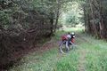
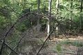
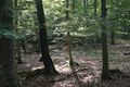
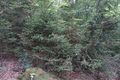
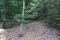
I started riding to the river rhine and followed it. After almost exactly one hour I reached the ferry in Rheinbrohl and crossed the stream. I followed the rhine for another 20 minutes before I turned left to Sinzig. Here I reached the river Ahr, that accompanied me for the next 60 kilometers and let me gain 250m of height without much effort.At the Ahr I made a stop in Ahrweiler to eat some onion tarte and drink some new wine. And I called my mother to proof that I eat enough. At half past three I reached Ahrdorf, where I had to leave the friendly river, but I could follow the rivulet Ahbach now and still rise slowly, until I came to Ahütte. From here the road turned steep, and after 90 km I was a little bit tired. I left the road at half past four and The way was really bad, but at least I could go downhill for a while. Then I entered a forest and soon I was close to the hash. A path to my left lead me even closer to it. I parked my bike and walked the last 50 m. The hash was easily accessible in a light forest. I took some pictures, builded a large X to mark the point and continued my way.
At 6 pm I reached Hillesheim. This part of the Eiffel (another german low mountain range) is famous for its detective stories, and Hillesheim is the center of these. So it has an own hotel for detective stories, and another hotel, that is a former prison. I took the later, and slept in a real prison cell. But I had dinner in the detective story-hotel and ate one of the best burgers I ever had.
With a height of 542 m this was the highest hashpoint that I've visited so far. A record, that won't last for long, by the way.
Tracklog
Photos
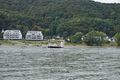
ferry in Bad Honnef
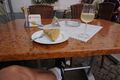
onion tarte and new wine
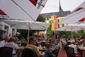
fair in Ahrweiler
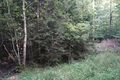
first view in hash-direction
proof of transport
proof
view to the west...
the north...
the east (luckily the hash wasn't there)...
and the south
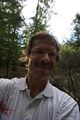
and the hasher
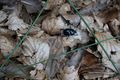
hash-bug (meetup?)
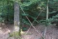
X
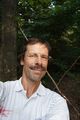
hasher in front of the X
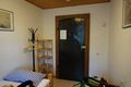
prison-cell


Achievements
DODO earned the Land geohash achievement
|
DODO earned the Bicycle geohash achievement
|