2016-09-25 49 8
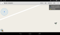
| Sun 25 Sep 2016 in 49,8: 49.2475990, 8.4175408 geohashing.info google osm bing/os kml crox |
Location
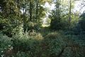
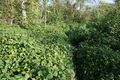
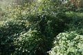
A blackberry copse near Philippsburg.
Participants
Plans
Both ladies are gone today so I have a whole day for hashing. But the hash is very close to my home. OK, I could try a walk geohash, 20 kilometers and ride back by train from Germersheim. Or I could go to my fourth attempt for a multi hash. From here via the Mannheim-hash to the Würzburg hash and further to the next train station is 140 KM. To much for my bike, but maybe I could make it with my bull? Of course the new shiny ribbon is more attractive, and so I'll go for it.
Expedition
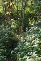
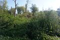
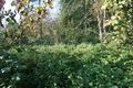
I started from home at 9:15. I decided to ride via Germersheim. The way was well known and I continued fast, although I selected the lowest support-level from my bull as I had to keep the energy budget. That let me ride with 27 - 30 kilometers per hour in the flat.In Germersheim I crossed the river rhine and soon came close to the hash. But that doesn't look good. A humid sink overgrown with dense blackberry copse. Would I be able to go 40 m inside or will my fourth attempt already fail at the first hash (what would be new, the three earlier attempts all failed at the second one)? Behind the hash was an overgrown path going quite in the right direction, and I could reduce the distance to half. Stil 20 m into dense copse. But what is that? It looks like someone has already entered the copse. A track of trampled down blackberries coiled up in the merely right direction. It was hard to follow as you didn't see where you step, but at least I got closer... and closer ... and close enough. Just in time as the track ended in front of an impenetrable copse. I took some pictures, returned to my mount and continued my ride.
Tracklog
See the second part of the adventure.
Photos
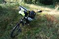
the bull
44 m into the copse
the overgrown path
the track into the copse
proof
looking back to the track

happy hasher
no way further
looking west
and north


Achievements
DODO earned the Land geohash achievement
|