2016-09-26 63 28
| Mon 26 Sep 2016 in 63,28: 63.7432142, 28.6030378 geohashing.info google osm bing/os kml crox |
Location
Lytösuo, Rasimäki, Valtimo. The point lies in a swampy area with some trees.
Participants
- Pastori
- The Wife
Plans
Starting on Friday night Pastori and Wife were planning their trip to a hashpoint on Monday. After all it was only 1.4 km away as the bird flies which is practically a coach potato achievement in these latitudes. So they were planning to take a hike through the fields and forests, singing as they went. It would a great opportunity for some exercise and fresh air and maybe even some fresh goodies from the forest. This was plan A.
Expedition
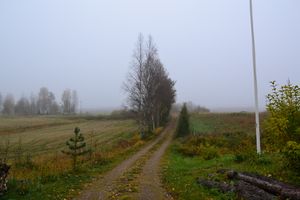
After a rainy weekend came the misty and damp reality of Monday morning. Pastori also remembered the realities of the terrain ahead of them which was full of long hay, thickets, swampy ditches and a huge population of deer fly. He also remembered that the elk hunting season had just began that past weekend and there was a chance of sudden elk hunting parties roaming the woods with their terrifying guns and dogs. And when you add to all that the fact that a bear (by their neighbor) and a wolverine (by Pastori and Wife) had been sighted around the area, Pastori decided to suggest plan B to Wife.
So off they went in their car, going around and driving for 8.9 km to reach the point and then walking for another 150 m, and after some mandatory troubles and some hashpoint dancing they reached the point at an accuracy of 0.469 m. It's weird how there always seems to be an easier route coming out of the forest than going in there. This time too there was a clear direct line marked by the forest keepers from the hashpoint back to the road where their car was parked, just 100 m from the car.
A nice little walk in the park... in the forest. The whole trip took 1 hour, 16.8 km of driving and 300 m of walking.
Additional photos
Achievements
Pastori and The Wife earned the Land geohash achievement
|


