2016-10-03 53 13
| Mon 3 Oct 2016 in 53,13: 53.6627550, 13.2654170 geohashing.info google osm bing/os kml crox |
Location
Today's location is between a creek and an allotment garden near Altentreptow.
Country: Germany; state: Mecklenburg-Vorpommern (EU:DE:MV); district: Mecklenburgische Seenplatte
Weather: light rain
Expedition
Danatar
Over the weekend I was in Stralsund for a training. I drove there on Thursday evening, passing the 2016-09-29 54 13 hashpoint on the way (just off the federal road I had to take, but in the middle of a huge field, also it was already very late in the evening. It would count as "not reached" but I didn't even get out of the car). The training was from Friday until Sunday. Because October 3rd (the following Monday) is the German national day I had that day off as well and used it to stay another day. My original plan was to go to Rügen island to visit the chalk cliffs and some other sightseeing attractions, then drive back to Dresden in the late afternoon/evening. When I found out that the 54 13 hashpoint fell near the beach on the northern coast of Rügen I planned to visit that one as well. But Sunday evening while having dinner with two nice women from the training they told me that they wanted to go to Rügen as well before going home so we decided to go together. We visited Granitz Castle in the morning, then went to the chalk cliffs near Sassnitz. There we paid the entrance fee and reached the lookout point just in time for the rain to start, so we left again. By that time it was already 4 p.m. and we had to hurry back to Stralsund for them to catch the train. Thus no expedition to the 54 13 hashpoint.
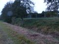
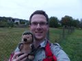
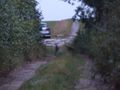
After dropping them off at Stralsund train station at 5 p.m. I started my journey to Dresden. After driving on the Autobahn A20 for a while I left it at the Altentreptow exit and drove to Altentreptow. By that time my fuel indicator had been at zero for 50 km so it was urgent to find a gas station (I know from experience that I can drive another ~70 km after the indicator is at zero). Luckily there was a gas station at Altentreptow and I was able to fill up 53.5 liters (official tank capacity: 54 liters. Yay, maximum tank usage!). Afterwards I drove along the state road further towards the hashpoint, then along a smaller track that led to and past an allotment garden. The hashpoint was on the other side so I followed the track (away from the spot) until I found another track leading off the one I was on. I parked the car and started walking. By that time (18:20) the negligible drizzle that had been going on for a while had turned to light rain. I walked along the track until I reached the Tuchmachergraben creek that runs past the hashpoint, then I walked along the edge of a meadow and along that creek. My shoes (the very beaten ones that I keep in the car for exactly these situations) we wet after a short while. I passed a large part of the allotment garden and the Tollense river until I came near the hashpoint. There I crossed the creek on a conveniently located plank "bridge" and I was at the hashpoint. It was on the bank of the creek next to the allotment garden's fence.
- Reached! -- Danatar (talk) @53.6628,13.2654 18:46, 3 October 2016 (GMT+02:00)
I took pictures and ate some celebratory Nibs candies (from the packs two other geohashers had given me - yeah you guys, they're still "fresh"). One the way back dusk fell. While I was walking along the track from the creek to the car I noticed two deer ahead of me. They noticed me as well and fled. But because that part of the track is lined with fences on both sides they couldn't escape. Again and again they fled for a bit when they saw me but after a while I reached them again. There was not much light at that point so my pictures didn't turn out well. I reached my car (19:10) and changed into my normal shoes and dry socks, then continued my journey, driving to the next village and from there to the Autobahn. I was back in Dresden (after having driven more than 600 km during the day) at midnight.
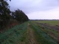
walking along the creek
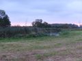
almost there
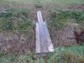
bridge
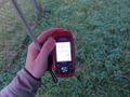
GPS
Coordinates reached!

panorama
deer in the dusk in the distance
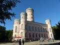
Jagdschloss Granitz on Rügen
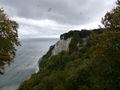
Victoria-Sicht chalk cliff on Rügen, windy just before the rain starts


My geohashiversary was on 2016-09-07. I didn't go to the hashpoint because I was leading a training the whole day. In the past year, my eighth year of geohashing, I:
- visited another 10 hashpoints (out of 12 tries), 1 new graticule
- cycled 88.3 km, walked 13.8 km, used public transport for 69.1 km and motorized vehicles for 87.2 km
- spent another 28 Euros while geohashing